Geographic Region: MOROCCO
Feature: GREAT ATLAS MTS.
|
Geographic Region: MOROCCO Feature: GREAT ATLAS MTS. |
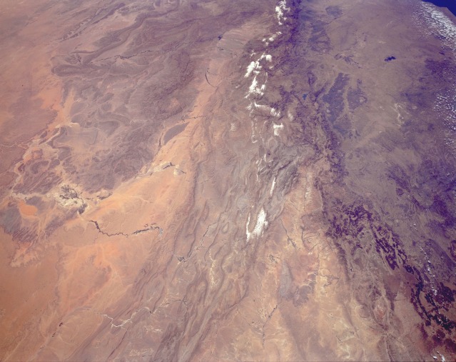 |
| STS059-L03-002 The Atlas Mountains, Morocco April 1994 Portions of the Atlas Mountains of central Morocco are captured in this low-oblique, southwest-looking photograph. Snow covers the higher peaks of the mountains, which have an average elevation of approximately 10 000 feet (3050 meters). The northern and western flanks are covered with oak, walnut, pine, and cedar forests. Numerous irrigated agricultural regions (dark green) are apparent west and northwest of the mountains. West of the irrigated areas, the Oum er Rbia River Reservoir (dark blue) can be seen. The Moulouya River Valley lies between the high and the middle Atlas ranges (northeast portion of the photograph). South of the snow-covered peaks of the high ranges are the folded ranges of the barren, rocky Anti-Atlas Mountains that have an average elevation of 3500 feet (1070 meters) and numerous small gullies and canyons. Many irrigated river valleys between the two ranges are visible--among them, a small turquoise reservoir in the Ziz River Valley. Because the Atlas Mountains were born of the same global convulsions that formed the Alps and the Himalayas, geologically they are more European than African. Atlas, the European name for the mountains, reflects the ancient Greeks' belief that this was the home of the god Atlas. In Arabic, the system is called the "Island of the West" because it is an "island" of relative fertility in a desert region. |
| Images: | All Available Images Low-Resolution 101k |
|
| Mission: | STS059 |
|
| Roll - Frame: | L03 - 2 |
|
| Geographical Name: | MOROCCO |
|
| Features: | GREAT ATLAS MTS. |
|
| Center Lat x Lon: | 32.0N x 6W |
|
| Film Exposure: | N | N=Normal exposure, U=Under exposed, O=Over exposed, F=out of Focus |
| Percentage of Cloud Cover-CLDP: | 0 |
|
| Camera:: | LH |
|
| Camera Tilt: | 51 | LO=Low Oblique, HO=High Oblique, NV=Near Vertical |
| Camera Focal Length: | 90 |
|
| Nadir to Photo Center Direction: | SW | The direction from the nadir to the center point, N=North, S=South, E=East, W=West |
| Stereo?: | Y | Y=Yes there is an adjacent picture of the same area, N=No there isn't |
| Orbit Number: | 115 |
|
| Date: | 19940416 | YYYYMMDD |
| Time: | 121757 | GMT HHMMSS |
| Nadir Lat: | 33.1N |
Latitude of suborbital point of spacecraft |
| Nadir Lon: | 3.9W |
Longitude of suborbital point of spacecraft |
| Sun Azimuth: | 181 | Clockwise angle in degrees from north to the sun measured at the nadir point |
| Space Craft Altitude: | 114 | nautical miles |
| Sun Elevation: | 67 | Angle in degrees between the horizon and the sun, measured at the nadir point |
| Land Views: | MOUNTAIN, VALLEY, PLAIN |
|
| Water Views: | |
|
| Atmosphere Views: | |
|
| Man Made Views: | AGRICULTURE |
|
| City Views: | |
|
Photo is not associated with any sequences | ||
| NASA Home Page |
JSC Home Page |
JSC Digital Image Collection |
Earth Science & Remote Sensing |
|
This service is provided by the International Space Station program and the JSC Earth Science & Remote Sensing Unit, ARES Division, Exploration Integration Science Directorate.

|