
Geographic Region: ROMANIA
Feature: CONSTANTA, ABBLOX R,AGR.
|
Geographic Region: ROMANIA Feature: CONSTANTA, ABBLOX R,AGR. |
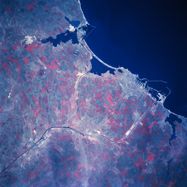 |
| STS059-098-114 Constanta Area, Romania April 1994 The Romanian port city, Constanta (1989 estimated population over 300000 people), is located along the southeast coast of Romania. Much of the infrastructure of the harbor facilities (various dikes, piers, and docks) can be seen outlined against the deep blue water of the western Black Sea. The irregular-shaped, dark features adjacent to the coast are lakes. The thin, dark lines that cross the coastal plain in this part of Romania are part of the Danube - Black Sea Canal. The canal was constructed during the last half of the 1900's to reduce (by approximately 140 miles - 225 km) the distance that shipping must travel on the Danube River to reach the Black Sea. The canal network is divided into a north canal that serves the port city of Navordari, while the main canal passes immediately south of Constanta. The coastal areas north and especially south of Constanta have fine, sandy beaches with a variety of resorts ranging from deluxe villas to campsites. The large, angular, reddish-looking (green vegetation is portrayed as shades of red on color infrared images) cultivated fields west and southwest of Constanta show extensive farming on the coastal plains of southeastern Romania. |
| Images: | All Available Images Low-Resolution 342k |
|
| Mission: | STS059 |
|
| Roll - Frame: | 98 - 114 |
|
| Geographical Name: | ROMANIA |
|
| Features: | CONSTANTA, ABBLOX R,AGR. |
|
| Center Lat x Lon: | 45.0N x 29.5E |
|
| Film Exposure: | N | N=Normal exposure, U=Under exposed, O=Over exposed, F=out of Focus |
| Percentage of Cloud Cover-CLDP: | 5 |
|
| Camera:: | HB |
|
| Camera Tilt: | 40 | LO=Low Oblique, HO=High Oblique, NV=Near Vertical |
| Camera Focal Length: | 250 |
|
| Nadir to Photo Center Direction: | NE | The direction from the nadir to the center point, N=North, S=South, E=East, W=West |
| Stereo?: | N | Y=Yes there is an adjacent picture of the same area, N=No there isn't |
| Orbit Number: | 113 |
|
| Date: | 19940416 | YYYYMMDD |
| Time: | 091646 | GMT HHMMSS |
| Nadir Lat: | 44.2N |
Latitude of suborbital point of spacecraft |
| Nadir Lon: | 28.1E |
Longitude of suborbital point of spacecraft |
| Sun Azimuth: | 158 | Clockwise angle in degrees from north to the sun measured at the nadir point |
| Space Craft Altitude: | 114 | nautical miles |
| Sun Elevation: | 54 | Angle in degrees between the horizon and the sun, measured at the nadir point |
| Land Views: | COAST, PLAIN |
|
| Water Views: | CANAL, BAY |
|
| Atmosphere Views: | |
|
| Man Made Views: | AGRICULTURE, URBAN AREA |
|
| City Views: | |
|
Photo is not associated with any sequences | ||
| NASA Home Page |
JSC Home Page |
JSC Digital Image Collection |
Earth Science & Remote Sensing |
|
This service is provided by the International Space Station program and the JSC Earth Science & Remote Sensing Unit, ARES Division, Exploration Integration Science Directorate.

|