Geographic Region: RUSSIAN FEDERATION
Feature: LAKE BAIKAL
|
Geographic Region: RUSSIAN FEDERATION Feature: LAKE BAIKAL |
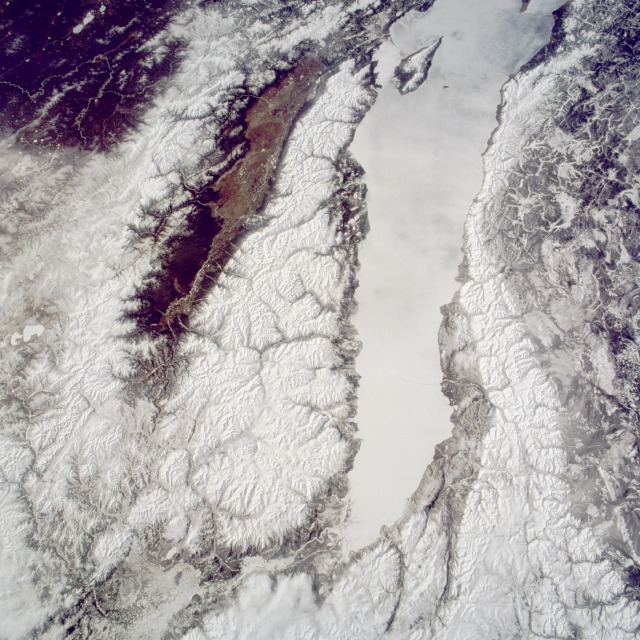 |
| STS059-090-086 Lake Baikal (Baykal), Russia April 1994 This south-looking, low-oblique photograph pictures the northern portion of Lake Baikal (Baykal) with ice covering its surface--the largest, deepest, and one of the oldest freshwater lakes in the world. It is also one of the most productive fishing lakes in eastern Russia. The Angara River can be seen entering the north end of the lake, and arrow-shaped Point Pov-Svyatoy juts out from the eastern shore (visible near the southern edge of the photograph). Lake Baikal was formed nearly 20 million years ago when faults in the Earth's crust caused a belt of rocks to sink, while mountains on either side were rising, forming a gigantic trench. Snow-covered mountain ranges are apparent, the Barguzinskiy Range to the east and the Baykal'skiy Mountains to the west of the lake. Fed by many rivers and streams, Lake Baikal is drained by the Angara River near the lake's southern end. The sickle-shaped lake is 395 miles (636 kilometers) long, up to 49 miles (79 kilometers) wide, and up to 5710 feet (1741 meters) deep. Because of its large volume of water, the lake has a moderating influence on the climate of the adjoining land. The lake and its shores are the habitat of many plants and animals found nowhere else in the world. |
| Images: | All Available Images Low-Resolution 162k |
|
| Mission: | STS059 |
|
| Roll - Frame: | 90 - 86 |
|
| Geographical Name: | RUSSIAN FEDERATION |
|
| Features: | LAKE BAIKAL |
|
| Center Lat x Lon: | 52.5N x 107.5E |
|
| Film Exposure: | N | N=Normal exposure, U=Under exposed, O=Over exposed, F=out of Focus |
| Percentage of Cloud Cover-CLDP: | 0 |
|
| Camera:: | HB |
|
| Camera Tilt: | LO | LO=Low Oblique, HO=High Oblique, NV=Near Vertical |
| Camera Focal Length: | 100 |
|
| Nadir to Photo Center Direction: | SW | The direction from the nadir to the center point, N=North, S=South, E=East, W=West |
| Stereo?: | Y | Y=Yes there is an adjacent picture of the same area, N=No there isn't |
| Orbit Number: | 108 |
|
| Date: | 19940416 | YYYYMMDD |
| Time: | GMT HHMMSS |
|
| Nadir Lat: | N |
Latitude of suborbital point of spacecraft |
| Nadir Lon: | E |
Longitude of suborbital point of spacecraft |
| Sun Azimuth: | Clockwise angle in degrees from north to the sun measured at the nadir point |
|
| Space Craft Altitude: | nautical miles |
|
| Sun Elevation: | Angle in degrees between the horizon and the sun, measured at the nadir point |
|
| Land Views: | MOUNTAIN, FOREST, VALLEY |
|
| Water Views: | LAKE, RIVER, SWAMP |
|
| Atmosphere Views: | |
|
| Man Made Views: | |
|
| City Views: | |
|
Photo is not associated with any sequences | ||
| NASA Home Page |
JSC Home Page |
JSC Digital Image Collection |
Earth Science & Remote Sensing |
|
This service is provided by the International Space Station program and the JSC Earth Science & Remote Sensing Unit, ARES Division, Exploration Integration Science Directorate.

|