
Geographic Region: USA-FLORIDA
Feature: ST. JOSEPH BAY
|
Geographic Region: USA-FLORIDA Feature: ST. JOSEPH BAY |
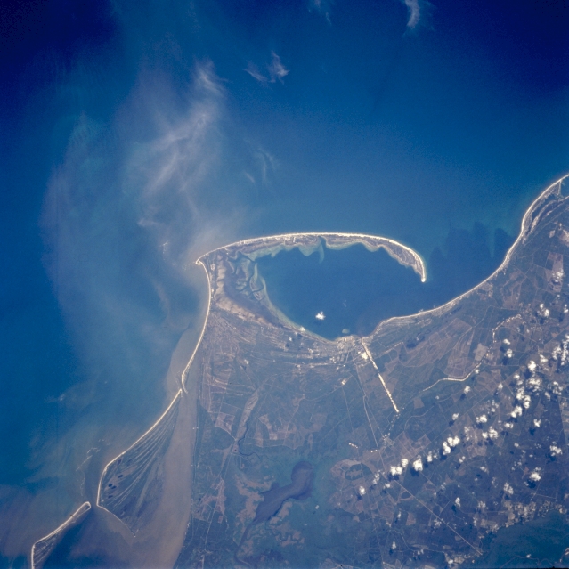 |
| STS059-089-039 Saint Joseph Bay, Florida, U.S.A. April 1994 A well-developed sand spit that curves generally northward forms Saint Joseph Bay and separates the bay from the blue Gulf of Mexico. Small, urban Port Saint Joe lies on the northeast coast of the bay, which is connected to the Intracoastal Waterway by a linear, highly reflective canal. Darker sediment is transported from Apalachicola Bay westward through Indian Pass north of Saint Vincent Island (bottom left). Most of the area is coastal wetlands (low-lying swamps). Widely scattered cumulus clouds are apparent (lower right corner). |
| Images: | All Available Images Low-Resolution 281k |
|
| Mission: | STS059 |
|
| Roll - Frame: | 89 - 39 |
|
| Geographical Name: | USA-FLORIDA |
|
| Features: | ST. JOSEPH BAY |
|
| Center Lat x Lon: | 29.5N x 85.5W |
|
| Film Exposure: | N | N=Normal exposure, U=Under exposed, O=Over exposed, F=out of Focus |
| Percentage of Cloud Cover-CLDP: | 10 |
|
| Camera:: | HB |
|
| Camera Tilt: | 19 | LO=Low Oblique, HO=High Oblique, NV=Near Vertical |
| Camera Focal Length: | 250 |
|
| Nadir to Photo Center Direction: | N | The direction from the nadir to the center point, N=North, S=South, E=East, W=West |
| Stereo?: | Y | Y=Yes there is an adjacent picture of the same area, N=No there isn't |
| Orbit Number: | 23 |
|
| Date: | 19940410 | YYYYMMDD |
| Time: | 201208 | GMT HHMMSS |
| Nadir Lat: | 28.8N |
Latitude of suborbital point of spacecraft |
| Nadir Lon: | 85.4W |
Longitude of suborbital point of spacecraft |
| Sun Azimuth: | 247 | Clockwise angle in degrees from north to the sun measured at the nadir point |
| Space Craft Altitude: | 120 | nautical miles |
| Sun Elevation: | 49 | Angle in degrees between the horizon and the sun, measured at the nadir point |
| Land Views: | ISLAND |
|
| Water Views: | CANAL, GULF, BAY, SWAMP |
|
| Atmosphere Views: | |
|
| Man Made Views: | |
|
| City Views: | |
|
Photo is not associated with any sequences | ||
| NASA Home Page |
JSC Home Page |
JSC Digital Image Collection |
Earth Science & Remote Sensing |
|
This service is provided by the International Space Station program and the JSC Earth Science & Remote Sensing Unit, ARES Division, Exploration Integration Science Directorate.

|