
Geographic Region: USA-NEVADA
Feature: LAS VEGAS AREA
|
Geographic Region: USA-NEVADA Feature: LAS VEGAS AREA |
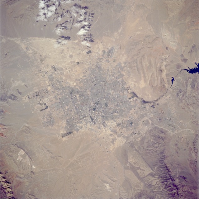 |
| STS059-086-055 Las Vegas, Nevada, U.S.A. April 1994 The tans and light browns of a desert environment provide a striking background for the setting of the dynamic, year-round resort and rapidly growing city of Las Vegas (approximate population of 750 000). Because clear atmosphere with low humidity exists, this near-vertical photograph reveals much Las Vegas urban infrastructure--the V-shaped runways of McCarran International Airport near the center of the photograph (along the southern edge of the city); numerous golf course fairways (dark, linear features) contrasting sharply with the nonvegetated land; the street network within the city (even famous Las Vegas Boulevard, the "Strip," with the well-known resort hotels); major highways that connect Las Vegas with surrounding states; and Nellis Air Force Base runways barely visible northeast of the city. Because of a lack of vegetation, several drainage patterns are very pronounced, especially the fan-shaped lighter area north of the city. The eastern side of the photograph shows the Las Vegas Wash, which is an extension of Las Vegas Bay (part of Lake Mead) that be seen gradually curving around a hilly area east of the city. Because it provides much detailed information, this type of photography is especially useful for urban and regional planners in monitoring and mapping changes to the physical landscape. |
| Images: | All Available Images Low-Resolution 111k |
|
| Mission: | STS059 |
|
| Roll - Frame: | 86 - 55 |
|
| Geographical Name: | USA-NEVADA |
|
| Features: | LAS VEGAS AREA |
|
| Center Lat x Lon: | 36.0N x 115W |
|
| Film Exposure: | N | N=Normal exposure, U=Under exposed, O=Over exposed, F=out of Focus |
| Percentage of Cloud Cover-CLDP: | 5 |
|
| Camera:: | HB |
|
| Camera Tilt: | 14 | LO=Low Oblique, HO=High Oblique, NV=Near Vertical |
| Camera Focal Length: | 250 |
|
| Nadir to Photo Center Direction: | NE | The direction from the nadir to the center point, N=North, S=South, E=East, W=West |
| Stereo?: | N | Y=Yes there is an adjacent picture of the same area, N=No there isn't |
| Orbit Number: | 40 |
|
| Date: | 19940411 | YYYYMMDD |
| Time: | 212017 | GMT HHMMSS |
| Nadir Lat: | 35.7N |
Latitude of suborbital point of spacecraft |
| Nadir Lon: | 115.4W |
Longitude of suborbital point of spacecraft |
| Sun Azimuth: | 225 | Clockwise angle in degrees from north to the sun measured at the nadir point |
| Space Craft Altitude: | 119 | nautical miles |
| Sun Elevation: | 55 | Angle in degrees between the horizon and the sun, measured at the nadir point |
| Land Views: | DESERT, MOUNTAIN |
|
| Water Views: | |
|
| Atmosphere Views: | |
|
| Man Made Views: | URBAN AREA, AIRPORT |
|
| City Views: | LAS VEGAS |
|
Photo is not associated with any sequences | ||
| NASA Home Page |
JSC Home Page |
JSC Digital Image Collection |
Earth Science & Remote Sensing |
|
This service is provided by the International Space Station program and the JSC Earth Science & Remote Sensing Unit, ARES Division, Exploration Integration Science Directorate.

|