
Geographic Region: USA-MONTANA
Feature: HELENA, CANYON FERRY L.
|
Geographic Region: USA-MONTANA Feature: HELENA, CANYON FERRY L. |
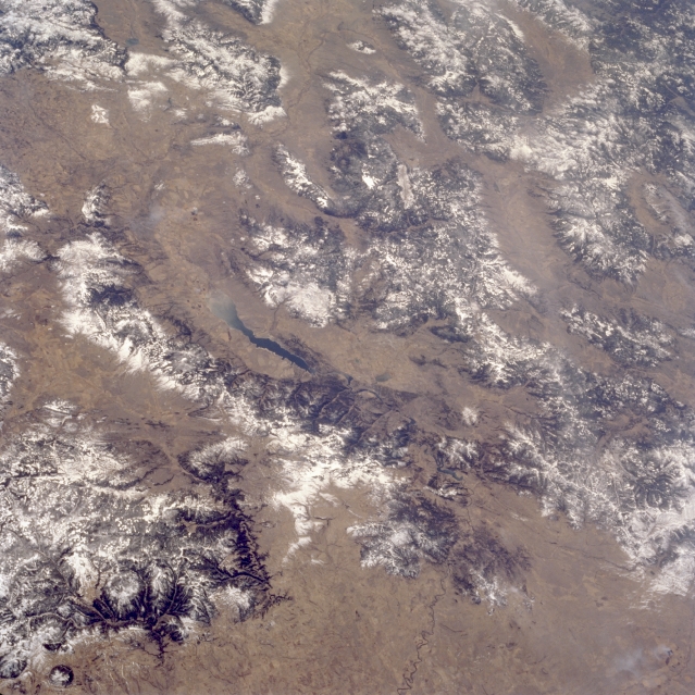 |
| STS059-085-097 Canyon Ferry Lake, Big Belt Mountains, Elkhorn Mountains, Montana, U.S.A. April 1994 Many rugged, snow-covered ranges within the Rocky Mountains of Montana are visible in this south-southwest-looking, low-oblique photograph. Discernible are Canyon Ferry Lake; to its east, the northwest-southeast-trending Big Belt Mountains; and still farther east, the Little Belt Mountains. The Elkhorn Mountains lie west of Canyon Ferry Lake, south of which is the northern portion of the Madison Range. West of the Madison Range are the Tobacco Root Mountains, the Pioneer Mountains, and to the northwest the Anaconda Range. Near the bottom right of the photograph is the southern extension of the Lewis and Clark Range. |
| Images: | All Available Images Low-Resolution 369k |
|
| Mission: | STS059 |
|
| Roll - Frame: | 85 - 97 |
|
| Geographical Name: | USA-MONTANA |
|
| Features: | HELENA, CANYON FERRY L. |
|
| Center Lat x Lon: | 46.5N x 112W |
|
| Film Exposure: | N | N=Normal exposure, U=Under exposed, O=Over exposed, F=out of Focus |
| Percentage of Cloud Cover-CLDP: | 5 |
|
| Camera:: | HB |
|
| Camera Tilt: | 52 | LO=Low Oblique, HO=High Oblique, NV=Near Vertical |
| Camera Focal Length: | 100 |
|
| Nadir to Photo Center Direction: | SW | The direction from the nadir to the center point, N=North, S=South, E=East, W=West |
| Stereo?: | N | Y=Yes there is an adjacent picture of the same area, N=No there isn't |
| Orbit Number: | 39 |
|
| Date: | 19940411 | YYYYMMDD |
| Time: | 194656 | GMT HHMMSS |
| Nadir Lat: | 48.1N |
Latitude of suborbital point of spacecraft |
| Nadir Lon: | 110.1W |
Longitude of suborbital point of spacecraft |
| Sun Azimuth: | 190 | Clockwise angle in degrees from north to the sun measured at the nadir point |
| Space Craft Altitude: | 118 | nautical miles |
| Sun Elevation: | 50 | Angle in degrees between the horizon and the sun, measured at the nadir point |
| Land Views: | MOUNTAIN, FAULT |
|
| Water Views: | LAKE |
|
| Atmosphere Views: | |
|
| Man Made Views: | |
|
| City Views: | |
|
Photo is not associated with any sequences | ||
| NASA Home Page |
JSC Home Page |
JSC Digital Image Collection |
Earth Science & Remote Sensing |
|
This service is provided by the International Space Station program and the JSC Earth Science & Remote Sensing Unit, ARES Division, Exploration Integration Science Directorate.

|