Geographic Region: KAZAKHSTAN
Feature: TROITSK, FACTORY SMOKE
|
Geographic Region: KAZAKHSTAN Feature: TROITSK, FACTORY SMOKE |
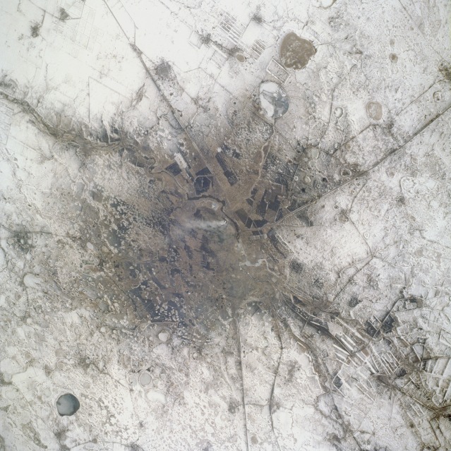 |
| STS059-075-030 Troitsk, Russia April 1994 Troitsk is a relatively small city (1990 population estimated at 90 000) located on a tributary of the upper Tobol River approximately 70 miles (110 kilometers) south of Chelyabinsk. Troitsk serves as a railroad junction and a supply and trading center for the southern Ural Mountains mining district. The Russia-Kazakhstan border is immediately south of Troitsk (and is included in this photograph). Several large, cultivated field patterns (elongated, rectangular shapes) are visible through the snow-covered landscape. Because the fields are large, it can be inferred that they are probably planted with spring wheat. Numerous circular, frozen lakes are scattered throughout the countryside around Troitsk. Some of the darker areas in this photograph show the results of burning fossil fuels, both in the city and in parts of the surrounding areas. A single smoke plume rises in the center of the scene. |
| Images: | All Available Images Low-Resolution 164k |
|
| Mission: | STS059 |
|
| Roll - Frame: | 75 - 30 |
|
| Geographical Name: | KAZAKHSTAN |
|
| Features: | TROITSK, FACTORY SMOKE |
|
| Center Lat x Lon: | 54.0N x 61.5E |
|
| Film Exposure: | N | N=Normal exposure, U=Under exposed, O=Over exposed, F=out of Focus |
| Percentage of Cloud Cover-CLDP: | 0 |
|
| Camera:: | HB |
|
| Camera Tilt: | 42 | LO=Low Oblique, HO=High Oblique, NV=Near Vertical |
| Camera Focal Length: | 250 |
|
| Nadir to Photo Center Direction: | NE | The direction from the nadir to the center point, N=North, S=South, E=East, W=West |
| Stereo?: | Y | Y=Yes there is an adjacent picture of the same area, N=No there isn't |
| Orbit Number: | 15 |
|
| Date: | 19940410 | YYYYMMDD |
| Time: | 081224 | GMT HHMMSS |
| Nadir Lat: | 52.7N |
Latitude of suborbital point of spacecraft |
| Nadir Lon: | 60.3E |
Longitude of suborbital point of spacecraft |
| Sun Azimuth: | 184 | Clockwise angle in degrees from north to the sun measured at the nadir point |
| Space Craft Altitude: | 117 | nautical miles |
| Sun Elevation: | 45 | Angle in degrees between the horizon and the sun, measured at the nadir point |
| Land Views: | |
|
| Water Views: | RIVER |
|
| Atmosphere Views: | PLUME |
|
| Man Made Views: | URBAN AREA, POLLUTION |
|
| City Views: | TROITSK |
|
Photo is not associated with any sequences | ||
| NASA Home Page |
JSC Home Page |
JSC Digital Image Collection |
Earth Science & Remote Sensing |
|
This service is provided by the International Space Station program and the JSC Earth Science & Remote Sensing Unit, ARES Division, Exploration Integration Science Directorate.

|