Geographic Region: JAPAN
Feature: OSAKA, OSAKA BAY, SHIPS
|
Geographic Region: JAPAN Feature: OSAKA, OSAKA BAY, SHIPS |
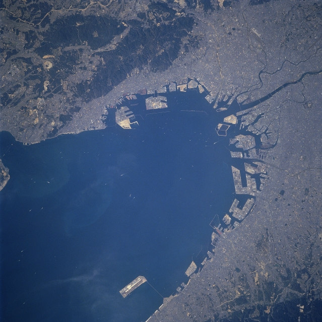 |
| STS059-071-027 Osaka/Kobi Area, Honshu, Japan April 1994 The location of the complex and extensive port and harbor facilities that handles cargo (containerized and other) from ocean going ships is apparent in this detailed view of Osaka and Kobe. These two port cities plus other urban areas that are integrated into one large metroplex are located along the northeast end of the Osaka Bay at the eastern end of Japan's Inland Sea. The two manmade islands (results of land reclamation projects-slightly above center) along the north edge of Osaka Bay are part of the modern Kobe port facilities, known as the Port Island Terminal (westernmost large island, part of the island still being constructed) and the roughly rectangular-shaped island immediately northeast of Port Island Terminal is Rokko Island Terminal. Many large manmade islands (shipping and receiving terminals) located along the east coast of Osaka Bay form the Port of Osaka, considered to be one of the foremost international ports of Japan. A causeway bridge connects Kansai International Airport (light-colored rectangular island) with the mainland. This bridge has also been constructed on reclaimed land and can be seen near the bottom center of the image. Several river channels (dark, linear, winding features), including the wide Yodo River (note the many bridges that cross the Yodo River), can be traced through the city of Osaka. The dark landscapes are low, forested mountains. |
| Images: | All Available Images Low-Resolution 340k |
|
| Mission: | STS059 |
|
| Roll - Frame: | 71 - 27 |
|
| Geographical Name: | JAPAN |
|
| Features: | OSAKA, OSAKA BAY, SHIPS |
|
| Center Lat x Lon: | 34.5N x 135.5E |
|
| Film Exposure: | N | N=Normal exposure, U=Under exposed, O=Over exposed, F=out of Focus |
| Percentage of Cloud Cover-CLDP: | 0 |
|
| Camera:: | HB |
|
| Camera Tilt: | 6 | LO=Low Oblique, HO=High Oblique, NV=Near Vertical |
| Camera Focal Length: | 250 |
|
| Nadir to Photo Center Direction: | N | The direction from the nadir to the center point, N=North, S=South, E=East, W=West |
| Stereo?: | Y | Y=Yes there is an adjacent picture of the same area, N=No there isn't |
| Orbit Number: | 13 |
|
| Date: | 19940410 | YYYYMMDD |
| Time: | 052159 | GMT HHMMSS |
| Nadir Lat: | 34.3N |
Latitude of suborbital point of spacecraft |
| Nadir Lon: | 135.4E |
Longitude of suborbital point of spacecraft |
| Sun Azimuth: | 239 | Clockwise angle in degrees from north to the sun measured at the nadir point |
| Space Craft Altitude: | 118 | nautical miles |
| Sun Elevation: | 48 | Angle in degrees between the horizon and the sun, measured at the nadir point |
| Land Views: | PLAIN, MOUNTAIN |
|
| Water Views: | BAY, RIVER |
|
| Atmosphere Views: | |
|
| Man Made Views: | URBAN AREA, AIRPORT, PORT |
|
| City Views: | |
|
Photo is not associated with any sequences | ||
| NASA Home Page |
JSC Home Page |
JSC Digital Image Collection |
Earth Science & Remote Sensing |
|
This service is provided by the International Space Station program and the JSC Earth Science & Remote Sensing Unit, ARES Division, Exploration Integration Science Directorate.

|