
Geographic Region: ALGERIA
Feature: PAN-GRAND ERG OCCIDENTAL
|
Geographic Region: ALGERIA Feature: PAN-GRAND ERG OCCIDENTAL |
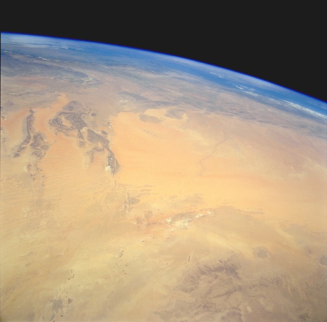 |
| STS059-238-088 Grand Erg Occidental, North Central Algeria April 1994 The Grand Erg Occidental (sand dune region) of north-central Algeria is the large sandy-looking area in the center of the photograph. This true desert region receives less than 10 inches (25 centimeters) of rainfall per year. The scale of this high-oblique, northwest-looking photograph does not permit the viewer to see the assortment of sandy landforms within the Grand Erg Occidental--linear dunes, star dunes, complex dunes, compound sheets, and sand streaks. The dark features to the southeast are the northwestern edge of the Tademait Plateau. The small dark specks near the southern edge of the photograph are very small oases and a few isolated circular field patterns (center-pivot irrigated fields). Immediately south of the large sand dunes region are several playas (dry lakebeds) where surface deposits of salt produce a highly reflective surface. The darker landforms near the western side of the photograph are slightly elevated bedrock outcrops whose ridge lines average 2000 feet (610 meters) above sea level. Near the horizon, the eastern end of the Atlas Mountains is barely discernible. |
| Images: | All Available Images Low-Resolution 60k |
|
| Mission: | STS059 |
|
| Roll - Frame: | 238 - 88 |
|
| Geographical Name: | ALGERIA |
|
| Features: | PAN-GRAND ERG OCCIDENTAL |
|
| Center Lat x Lon: | 30.5N x .0E |
|
| Film Exposure: | N | N=Normal exposure, U=Under exposed, O=Over exposed, F=out of Focus |
| Percentage of Cloud Cover-CLDP: | 5 |
|
| Camera:: | HB |
|
| Camera Tilt: | HO | LO=Low Oblique, HO=High Oblique, NV=Near Vertical |
| Camera Focal Length: | 100 |
|
| Nadir to Photo Center Direction: | N | The direction from the nadir to the center point, N=North, S=South, E=East, W=West |
| Stereo?: | Y | Y=Yes there is an adjacent picture of the same area, N=No there isn't |
| Orbit Number: | 131 |
|
| Date: | 19940417 | YYYYMMDD |
| Time: | 115836 | GMT HHMMSS |
| Nadir Lat: | 27.4N |
Latitude of suborbital point of spacecraft |
| Nadir Lon: | .5E |
Longitude of suborbital point of spacecraft |
| Sun Azimuth: | 181 | Clockwise angle in degrees from north to the sun measured at the nadir point |
| Space Craft Altitude: | 114 | nautical miles |
| Sun Elevation: | 73 | Angle in degrees between the horizon and the sun, measured at the nadir point |
| Land Views: | DESERT, DUNE, PLATEAU |
|
| Water Views: | |
|
| Atmosphere Views: | |
|
| Man Made Views: | |
|
| City Views: | |
|
Photo is not associated with any sequences | ||
| NASA Home Page |
JSC Home Page |
JSC Digital Image Collection |
Earth Science & Remote Sensing |
|
This service is provided by the International Space Station program and the JSC Earth Science & Remote Sensing Unit, ARES Division, Exploration Integration Science Directorate.

|