Geographic Region: SPAIN
Feature: PAN-STRAIT OF GIBRALTAR
|
Geographic Region: SPAIN Feature: PAN-STRAIT OF GIBRALTAR |
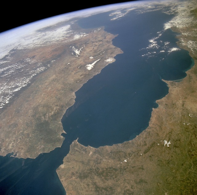 |
| STS059-238-074 Strait of Gibraltar, Spain and Morocco April 1994 The Strait of Gibraltar provides a natural physical barrier between the countries of Spain (north) and Morocco (south). In geologic terms, the 10-mile (16-kilometer) strait that separates the two countries, as well as Europe and Africa, is located where the two major tectonic plates--the Eurasian Plate and the African Plate--collide. This high-oblique, northeast-looking photograph shows the mountainous northern coast of Morocco and the coastal mountains of southern Spain, including the dagger-shaped, snow-covered Sierra Nevada Mountains of southeastern Spain. The Guadalquivir River flows from east to west along the base of the Sierra Morena Mountains in southern Spain. The famous British city of Gibraltar is located on the wedge-shaped peninsula on the east side of the bay in the southernmost protrusion of Spain. The city of Ceuta is a Spanish enclave on the extreme northeastern coast of Morocco. Ceuta, a free port with a large harbor, has remained under Spanish control since 1580. The Atlantic Ocean, Straits of Gibraltar, and Alboran Sea (the westernmost portion of the Mediterranean Sea) separate Spain on the left from Morocco on the right. Algeciras Harbor is the prominent notch cut out of the eastern end of the north shore of the Strait; the Rock of Gibraltar is the tiny arrowhead that separates the notch from the Alboran Sea. The Sierra Nevada, farther away down the Spanish coast, lives up to its name in this April scene. The difference in elevation between the Sierra Morena and the Guadalquivir River valley is highlighted nicely by cumulus clouds. Tangier, Morocco can be seen as a light-toned spot on the southern shore of the Strait, near the entrance to the Atlantic Ocean. |
| Images: | All Available Images Low-Resolution 102k |
|
| Mission: | STS059 |
|
| Roll - Frame: | 238 - 74 |
|
| Geographical Name: | SPAIN |
|
| Features: | PAN-STRAIT OF GIBRALTAR |
|
| Center Lat x Lon: | 37.0N x 4W |
|
| Film Exposure: | N | N=Normal exposure, U=Under exposed, O=Over exposed, F=out of Focus |
| Percentage of Cloud Cover-CLDP: | 15 |
|
| Camera:: | HB |
|
| Camera Tilt: | HO | LO=Low Oblique, HO=High Oblique, NV=Near Vertical |
| Camera Focal Length: | 100 |
|
| Nadir to Photo Center Direction: | NE | The direction from the nadir to the center point, N=North, S=South, E=East, W=West |
| Stereo?: | Y | Y=Yes there is an adjacent picture of the same area, N=No there isn't |
| Orbit Number: | 131 |
|
| Date: | 19940417 | YYYYMMDD |
| Time: | 115617 | GMT HHMMSS |
| Nadir Lat: | 34.7N |
Latitude of suborbital point of spacecraft |
| Nadir Lon: | 5.9W |
Longitude of suborbital point of spacecraft |
| Sun Azimuth: | 164 | Clockwise angle in degrees from north to the sun measured at the nadir point |
| Space Craft Altitude: | 114 | nautical miles |
| Sun Elevation: | 65 | Angle in degrees between the horizon and the sun, measured at the nadir point |
| Land Views: | MOUNTAIN, COAST, PLAIN |
|
| Water Views: | SEA, STRAIT, RIVER, INLET |
|
| Atmosphere Views: | |
|
| Man Made Views: | URBAN AREA |
|
| City Views: | |
|
Photo is not associated with any sequences | ||
| NASA Home Page |
JSC Home Page |
JSC Digital Image Collection |
Earth Science & Remote Sensing |
|
This service is provided by the International Space Station program and the JSC Earth Science & Remote Sensing Unit, ARES Division, Exploration Integration Science Directorate.

|