
Geographic Region: THAILAND
Feature: BANGKOK
|
Geographic Region: THAILAND Feature: BANGKOK |
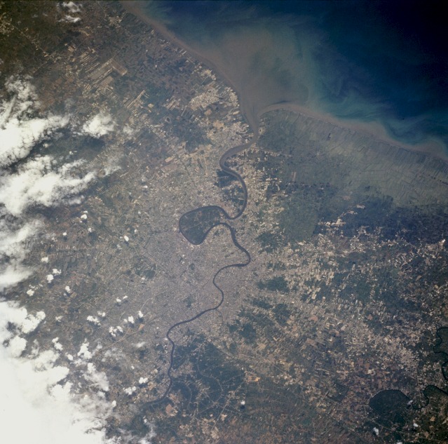 |
| STS059-235-31 Bangkok, Thailand April 1994 Bangkok, featured in this southeast-looking, low-oblique photograph, is the capital of Thailand and one of the leading cities in Southeast Asia. Situated on the east bank of the Chao Phraya River 25 miles (40 kilometers) above the river's entry into the Gulf of Thailand, Bangkok lies in the heart of Thailand's major commercial rice-growing region. Bangkok's manufacturing products include rice, paper, textiles, food products, and electrical goods; other industries include oil refineries, sawmills, shipyards, motor vehicle assembly plants, and tourism. As a world-famous jewelry trading center, Bangkok deals in silver, bronze, and precious stones. Hundreds of Buddhist temples are scattered throughout the city. Since 1955, Bangkok has been the site of the headquarters of the Southeast Asia Treaty Organization and the United Nations Economic Commission for Asia and the Far East. The city lies at or below sea level (land subsidence is a severe problem) and is riddled by a network of canals filled with boat traffic and "islands" of floating garbage. Traffic congestion on narrow streets and other transportation arteries is also problematic. With its air and water fouled by a large and growing population, Bangkok has the unpleasant distinction of being the world's most polluted city. |
| Images: | All Available Images Low-Resolution 141k |
|
| Mission: | STS059 |
|
| Roll - Frame: | 235 - 31 |
|
| Geographical Name: | THAILAND |
|
| Features: | BANGKOK |
|
| Center Lat x Lon: | 14.0N x 100.5E |
|
| Film Exposure: | N | N=Normal exposure, U=Under exposed, O=Over exposed, F=out of Focus |
| Percentage of Cloud Cover-CLDP: | 10 |
|
| Camera:: | HB |
|
| Camera Tilt: | 27 | LO=Low Oblique, HO=High Oblique, NV=Near Vertical |
| Camera Focal Length: | 250 |
|
| Nadir to Photo Center Direction: | E | The direction from the nadir to the center point, N=North, S=South, E=East, W=West |
| Stereo?: | N | Y=Yes there is an adjacent picture of the same area, N=No there isn't |
| Orbit Number: | 127 |
|
| Date: | 19940417 | YYYYMMDD |
| Time: | 060753 | GMT HHMMSS |
| Nadir Lat: | 14.4N |
Latitude of suborbital point of spacecraft |
| Nadir Lon: | 99.6E |
Longitude of suborbital point of spacecraft |
| Sun Azimuth: | 253 | Clockwise angle in degrees from north to the sun measured at the nadir point |
| Space Craft Altitude: | 115 | nautical miles |
| Sun Elevation: | 78 | Angle in degrees between the horizon and the sun, measured at the nadir point |
| Land Views: | COAST, PLAIN |
|
| Water Views: | BAY, RIVER, SEDIMENT |
|
| Atmosphere Views: | |
|
| Man Made Views: | URBAN AREA, AGRICULTURE |
|
| City Views: | BANGKOK |
|
Photo is not associated with any sequences | ||
| NASA Home Page |
JSC Home Page |
JSC Digital Image Collection |
Earth Science & Remote Sensing |
|
This service is provided by the International Space Station program and the JSC Earth Science & Remote Sensing Unit, ARES Division, Exploration Integration Science Directorate.

|