
Geographic Region: AUSTRALIA-NSW
Feature: NEWCASTLE, COASTAL DUNES
|
Geographic Region: AUSTRALIA-NSW Feature: NEWCASTLE, COASTAL DUNES |
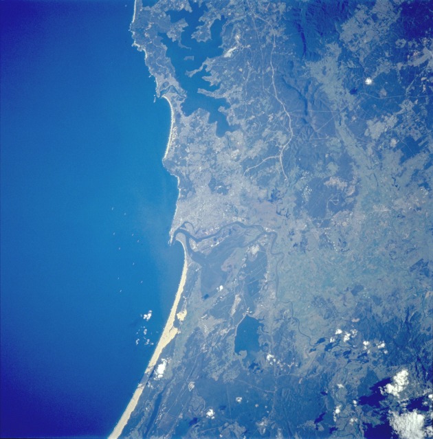 |
| STS059-235-003 Newcastle, New South Wales, Australia April 1994 Located 100 miles (160 kilometers) northeast of Sydney, Newcastle is a growing industrial seaport with a population approaching 500 000. Combining the advantages of coastal location and proximity to nearby coal fields, Newcastle is visible in the center of this nearly vertical photograph. Meandering along the northern edge of the city is the Hunter River. Several other identifiable features surround the city--Grahamstown Lake to the north; broad, sandy beaches to the northeast; a narrow strip of sandy beaches to the south; a narrow, highly reflective swath through the forests to the southwest (perhaps a new ground transportation link under construction); and ground scars to the west that were created by surface mining activities in the forested foothills of the Great Dividing Range, which extends along the entire east coast of Australia. |
| Images: | All Available Images Low-Resolution 113k |
|
| Mission: | STS059 |
|
| Roll - Frame: | 235 - 3 |
|
| Geographical Name: | AUSTRALIA-NSW |
|
| Features: | NEWCASTLE, COASTAL DUNES |
|
| Center Lat x Lon: | 33S x 151.5E |
|
| Film Exposure: | N | N=Normal exposure, U=Under exposed, O=Over exposed, F=out of Focus |
| Percentage of Cloud Cover-CLDP: | 5 |
|
| Camera:: | HB |
|
| Camera Tilt: | 36 | LO=Low Oblique, HO=High Oblique, NV=Near Vertical |
| Camera Focal Length: | 250 |
|
| Nadir to Photo Center Direction: | S | The direction from the nadir to the center point, N=North, S=South, E=East, W=West |
| Stereo?: | Y | Y=Yes there is an adjacent picture of the same area, N=No there isn't |
| Orbit Number: | 126 |
|
| Date: | 19940417 | YYYYMMDD |
| Time: | 045254 | GMT HHMMSS |
| Nadir Lat: | 31.6S |
Latitude of suborbital point of spacecraft |
| Nadir Lon: | 151.6E |
Longitude of suborbital point of spacecraft |
| Sun Azimuth: | 307 | Clockwise angle in degrees from north to the sun measured at the nadir point |
| Space Craft Altitude: | 115 | nautical miles |
| Sun Elevation: | 30 | Angle in degrees between the horizon and the sun, measured at the nadir point |
| Land Views: | COAST, HILL, FOREST |
|
| Water Views: | LAKE, RIVER |
|
| Atmosphere Views: | |
|
| Man Made Views: | |
|
| City Views: | |
|
Photo is not associated with any sequences | ||
| NASA Home Page |
JSC Home Page |
JSC Digital Image Collection |
Earth Science & Remote Sensing |
|
This service is provided by the International Space Station program and the JSC Earth Science & Remote Sensing Unit, ARES Division, Exploration Integration Science Directorate.

|