
Geographic Region: USA-CALIFORNIA
Feature: SANTA BARBARA, SUNGLINT
|
Geographic Region: USA-CALIFORNIA Feature: SANTA BARBARA, SUNGLINT |
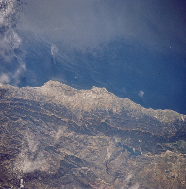 |
| STS059-234-069 Santa Barbara, Goleta, and Santa Ynez Mountains, California, U.S.A. April 1994 The coastal resort cities of Santa Barbara and Goleta are barely discernible in this near-vertical photograph. North of Santa Barbara and Goleta, paralleling the coast, lie the east-west-trending, forested Santa Ynez Mountains, north of which lies Lake Cachuma. Farther north, the San Rafael Mountains are partially obscured by clouds. Santa Barbara, known for its prevalent Spanish architecture, has many recreational facilities and electronic, aerospace, oil, and orchid industries. The Santa Barbara Channel is captured in the upper half of the photograph. |
| Images: | All Available Images Low-Resolution 316k |
|
| Mission: | STS059 |
|
| Roll - Frame: | 234 - 69 |
|
| Geographical Name: | USA-CALIFORNIA |
|
| Features: | SANTA BARBARA, SUNGLINT |
|
| Center Lat x Lon: | 34.5N x 120W |
|
| Film Exposure: | N | N=Normal exposure, U=Under exposed, O=Over exposed, F=out of Focus |
| Percentage of Cloud Cover-CLDP: | 5 |
|
| Camera:: | HB |
|
| Camera Tilt: | NV | LO=Low Oblique, HO=High Oblique, NV=Near Vertical |
| Camera Focal Length: | 250 |
|
| Nadir to Photo Center Direction: | SW | The direction from the nadir to the center point, N=North, S=South, E=East, W=West |
| Stereo?: | Y | Y=Yes there is an adjacent picture of the same area, N=No there isn't |
| Orbit Number: | 136 |
|
| Date: | 19940417 | YYYYMMDD |
| Time: | 191930 | GMT HHMMSS |
| Nadir Lat: | 35.3N |
Latitude of suborbital point of spacecraft |
| Nadir Lon: | 119.1W |
Longitude of suborbital point of spacecraft |
| Sun Azimuth: | 159 | Clockwise angle in degrees from north to the sun measured at the nadir point |
| Space Craft Altitude: | 113 | nautical miles |
| Sun Elevation: | 64 | Angle in degrees between the horizon and the sun, measured at the nadir point |
| Land Views: | MOUNTAIN, COAST, FAULT |
|
| Water Views: | LAKE |
|
| Atmosphere Views: | |
|
| Man Made Views: | |
|
| City Views: | |
|
Photo is not associated with any sequences | ||
| NASA Home Page |
JSC Home Page |
JSC Digital Image Collection |
Earth Science & Remote Sensing |
|
This service is provided by the International Space Station program and the JSC Earth Science & Remote Sensing Unit, ARES Division, Exploration Integration Science Directorate.

|