
Geographic Region: USA-VIRGINIA
Feature: NORFOLK, JAMES RIVER,SED
|
Geographic Region: USA-VIRGINIA Feature: NORFOLK, JAMES RIVER,SED |
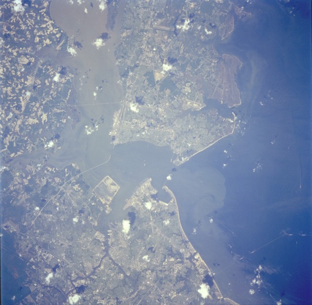 |
| STS059-234-045 Hampton Roads, Norfolk, and Newport News Area, Virginia, U.S.A. April 1994 This near-vertical photograph shows the area of Hampton Roads, Norfolk, and Newport News in southeastern Virginia. Hampton Roads, with one of the finest natural harbors in the world, has a deep water channel (near the center of the photograph) 4 miles (6 kilometers) long and 40 feet (12 meters) deep, through which the waters of the James, Nansemond, and Elizabeth Rivers pass into Chesapeake Bay. The Hampton Roads harbor was the site of the Civil War battle between the ironclad ships, Monitor and Merrimack, in March l862. Southeast of Hampton Roads is Norfolk, a port of entry and major commercial, industrial, shipping, and distribution center. Its industries include shipbuilding; meat and seafood processing; automobile assembly; and the manufacture of fertilizers, farm implements, chemicals, textiles, and peanut oil. Norfolk, along with the city of Portsmouth to its west, forms an extensive naval military complex. As the largest operating military base in the United States, this complex includes a major naval air station, a supply center, and numerous training and operational facilities. The Chesapeake Bay Bridge Tunnel (barely discernible near the east edge of the photograph) links Norfolk with the Delmarva Peninsula (not within the photograph) to the north. West of Hampton Roads at the mouth of the James River is Newport News, a major port for transatlantic and intracoastal shipping and one of the largest shipbuilding and repair centers in the world. Major products manufactured in Newport News include building materials, textiles, metal products, and radar and electronic equipment. Other industries include oil refining, railroad shops, and seafood processing plants. |
| Images: | All Available Images Low-Resolution 108k |
|
| Mission: | STS059 |
|
| Roll - Frame: | 234 - 45 |
|
| Geographical Name: | USA-VIRGINIA |
|
| Features: | NORFOLK, JAMES RIVER,SED |
|
| Center Lat x Lon: | 37.0N x 76.5W |
|
| Film Exposure: | N | N=Normal exposure, U=Under exposed, O=Over exposed, F=out of Focus |
| Percentage of Cloud Cover-CLDP: | 5 |
|
| Camera:: | HB |
|
| Camera Tilt: | 15 | LO=Low Oblique, HO=High Oblique, NV=Near Vertical |
| Camera Focal Length: | 250 |
|
| Nadir to Photo Center Direction: | W | The direction from the nadir to the center point, N=North, S=South, E=East, W=West |
| Stereo?: | Y | Y=Yes there is an adjacent picture of the same area, N=No there isn't |
| Orbit Number: | 134 |
|
| Date: | 19940417 | YYYYMMDD |
| Time: | 162135 | GMT HHMMSS |
| Nadir Lat: | 37.1N |
Latitude of suborbital point of spacecraft |
| Nadir Lon: | 76W |
Longitude of suborbital point of spacecraft |
| Sun Azimuth: | 158 | Clockwise angle in degrees from north to the sun measured at the nadir point |
| Space Craft Altitude: | 113 | nautical miles |
| Sun Elevation: | 62 | Angle in degrees between the horizon and the sun, measured at the nadir point |
| Land Views: | COAST |
|
| Water Views: | BAY, RIVER, ESTUARY, SEDIMENT |
|
| Atmosphere Views: | |
|
| Man Made Views: | URBAN AREA, AIRPORT |
|
| City Views: | |
|
Photo is not associated with any sequences | ||
| NASA Home Page |
JSC Home Page |
JSC Digital Image Collection |
Earth Science & Remote Sensing |
|
This service is provided by the International Space Station program and the JSC Earth Science & Remote Sensing Unit, ARES Division, Exploration Integration Science Directorate.

|