
Geographic Region: YEMEN
Feature: PAN-NE TO EMPTY QUARTER
|
Geographic Region: YEMEN Feature: PAN-NE TO EMPTY QUARTER |
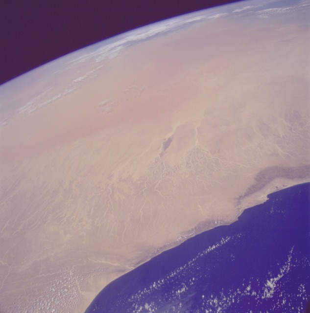 |
| STS059-230-028 Ar Rub' al Khali (Empty Quarter), Oman and Saudi Arabia April 1994 The orange sand dunes of the eastern Ar Rub' al Khali Desert (empty quarter) are pictured in this spectacular, high-oblique, north-looking photograph. More than 300 miles (500 kilometers) wide and nearly 700 miles (1100 kilometers) long, this hot, arid desert dominates the landscape of the southeastern Arabian Peninsula. The absence of rainfall and the scarcity of vegetation make this area uninhabitable, even by pastoral nomads. Bedouin tribesmen, who live around the fringes of this great desert, dare not enter the region during the summer when temperatures soar above 122 degrees Fahrenheit (50 degrees Celsius) during the day and drop below 32 degrees Fahrenheit (0 degrees Celsius) at night. Sand dunes, whose average height is almost 660 feet (200 meters), can rise more than 1000 feet (330 meters). So difficult is this desert for humans to penetrate, much of the region remains unexplored. Visible in the photograph are the coast of Oman, the nearby high plateau that descends in elevation toward the sand dunes (near the center of the photograph), and clouds that cover the central portion of the Persian Gulf (north of the sand dunes near the horizon of the photograph). |
| Images: | All Available Images Low-Resolution 63k |
|
| Mission: | STS059 |
|
| Roll - Frame: | 230 - 28 |
|
| Geographical Name: | YEMEN |
|
| Features: | PAN-NE TO EMPTY QUARTER |
|
| Center Lat x Lon: | 18.5N x 54.0E |
|
| Film Exposure: | N | N=Normal exposure, U=Under exposed, O=Over exposed, F=out of Focus |
| Percentage of Cloud Cover-CLDP: | 5 |
|
| Camera:: | HB |
|
| Camera Tilt: | HO | LO=Low Oblique, HO=High Oblique, NV=Near Vertical |
| Camera Focal Length: | 40 |
|
| Nadir to Photo Center Direction: | N | The direction from the nadir to the center point, N=North, S=South, E=East, W=West |
| Stereo?: | N | Y=Yes there is an adjacent picture of the same area, N=No there isn't |
| Orbit Number: | 145 |
|
| Date: | 19940418 | YYYYMMDD |
| Time: | 084315 | GMT HHMMSS |
| Nadir Lat: | 15.7N |
Latitude of suborbital point of spacecraft |
| Nadir Lon: | 53.4E |
Longitude of suborbital point of spacecraft |
| Sun Azimuth: | 222 | Clockwise angle in degrees from north to the sun measured at the nadir point |
| Space Craft Altitude: | 114 | nautical miles |
| Sun Elevation: | 84 | Angle in degrees between the horizon and the sun, measured at the nadir point |
| Land Views: | DESERT, DUNE, PLATEAU |
|
| Water Views: | |
|
| Atmosphere Views: | |
|
| Man Made Views: | |
|
| City Views: | |
|
Photo is not associated with any sequences | ||
| NASA Home Page |
JSC Home Page |
JSC Digital Image Collection |
Earth Science & Remote Sensing |
|
This service is provided by the International Space Station program and the JSC Earth Science & Remote Sensing Unit, ARES Division, Exploration Integration Science Directorate.

|