Geographic Region: GERMANY
Feature: MINING AREA NEAR COTTBUS
|
Geographic Region: GERMANY Feature: MINING AREA NEAR COTTBUS |
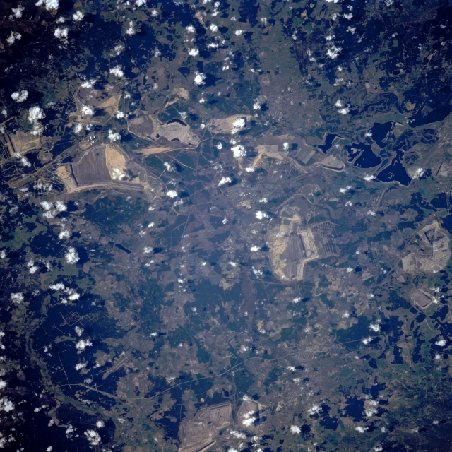 |
| STS059-228-019 Strip Mining, Cottbus Area, Germany April, 1994 Numerous lignite strip mines can be seen in this northeast-looking view. The region shown on the image includes the German city of Cottbus (or Kottbus) midway between the upper left and center of the image. Cottbus is located on the Spree River (not discernible), and is an industrial center and rail junction that is located 64 miles (103 km) southeast of Berlin (not visible in the image). An airport runway located south of the important textile center of Forst (upper right of the image) is visible (upper right quadrant of the image). Below the center of the image is the small industrial city of Hoyerswerda. A row of strip mines extends west to east across the image to the south of the city. Hoyerswerda is a major glass-manufacturing center. |
| Images: | All Available Images Low-Resolution 388k |
|
| Mission: | STS059 |
|
| Roll - Frame: | 228 - 19 |
|
| Geographical Name: | GERMANY |
|
| Features: | MINING AREA NEAR COTTBUS |
|
| Center Lat x Lon: | 51.5N x 14.5E |
|
| Film Exposure: | N | N=Normal exposure, U=Under exposed, O=Over exposed, F=out of Focus |
| Percentage of Cloud Cover-CLDP: | 5 |
|
| Camera:: | HB |
|
| Camera Tilt: | 24 | LO=Low Oblique, HO=High Oblique, NV=Near Vertical |
| Camera Focal Length: | 250 |
|
| Nadir to Photo Center Direction: | N | The direction from the nadir to the center point, N=North, S=South, E=East, W=West |
| Stereo?: | N | Y=Yes there is an adjacent picture of the same area, N=No there isn't |
| Orbit Number: | 145 |
|
| Date: | 19940418 | YYYYMMDD |
| Time: | 083120 | GMT HHMMSS |
| Nadir Lat: | 50.7N |
Latitude of suborbital point of spacecraft |
| Nadir Lon: | 14.7E |
Longitude of suborbital point of spacecraft |
| Sun Azimuth: | 129 | Clockwise angle in degrees from north to the sun measured at the nadir point |
| Space Craft Altitude: | 112 | nautical miles |
| Sun Elevation: | 40 | Angle in degrees between the horizon and the sun, measured at the nadir point |
| Land Views: | PLAIN, HILL |
|
| Water Views: | RIVER, LAKE |
|
| Atmosphere Views: | |
|
| Man Made Views: | MINING |
|
| City Views: | |
|
Photo is not associated with any sequences | ||
| NASA Home Page |
JSC Home Page |
JSC Digital Image Collection |
Earth Science & Remote Sensing |
|
This service is provided by the International Space Station program and the JSC Earth Science & Remote Sensing Unit, ARES Division, Exploration Integration Science Directorate.

|