
Geographic Region: CAYMAN ISLANDS
Feature: GRAND CAYMAN ISLAND
|
Geographic Region: CAYMAN ISLANDS Feature: GRAND CAYMAN ISLAND |
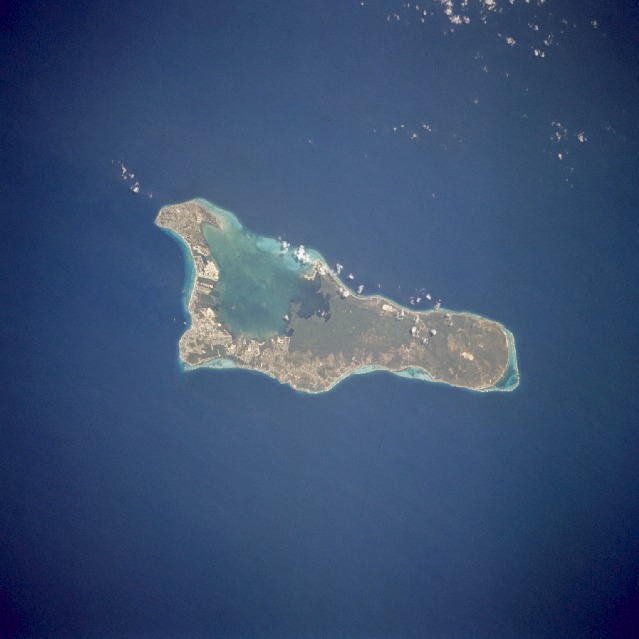 |
| STS059-227-042 Grand Cayman, Cayman Islands April 1994 The island of Grand Cayman, a British dependency that covers 76 square miles (197 square kilometers) in the northwest Caribbean Sea, is visible in this near-vertical photograph. Geologically similar to The Bahamas, Grand Cayman is a low-lying, limestone island located on top of a submarine ridge. The city of George Town, the capital and chief port of the Cayman Islands, can be seen at the southwest end of the island. Grand Cayman was discovered in 1503 by Christopher Columbus but was never occupied by Spain. The island was settled in 1734 by English colonists from the island of Jamaica, approximately 200 miles (320 kilometers) to the southeast. The word "Cayman" is derived from the Carib Indian word for alligator, apparently because early British visitors saw large lizards (probably iguanas), which they mistook for alligators. Grand Cayman's 7-mile beach can be seen on the western side of the island. With exotic coral reefs off its shores, Grand Cayman is a mecca for divers. Today, tourism is the major industry of the island. |
| Images: | All Available Images Low-Resolution 66k |
|
| Mission: | STS059 |
|
| Roll - Frame: | 227 - 42 |
|
| Geographical Name: | CAYMAN ISLANDS |
|
| Features: | GRAND CAYMAN ISLAND |
|
| Center Lat x Lon: | 19.0N x 81W |
|
| Film Exposure: | N | N=Normal exposure, U=Under exposed, O=Over exposed, F=out of Focus |
| Percentage of Cloud Cover-CLDP: | 0 |
|
| Camera:: | HB |
|
| Camera Tilt: | 36 | LO=Low Oblique, HO=High Oblique, NV=Near Vertical |
| Camera Focal Length: | 100 |
|
| Nadir to Photo Center Direction: | E | The direction from the nadir to the center point, N=North, S=South, E=East, W=West |
| Stereo?: | N | Y=Yes there is an adjacent picture of the same area, N=No there isn't |
| Orbit Number: | 103 |
|
| Date: | 19940415 | YYYYMMDD |
| Time: | 183800 | GMT HHMMSS |
| Nadir Lat: | 18.5N |
Latitude of suborbital point of spacecraft |
| Nadir Lon: | 82.3W |
Longitude of suborbital point of spacecraft |
| Sun Azimuth: | 245 | Clockwise angle in degrees from north to the sun measured at the nadir point |
| Space Craft Altitude: | 115 | nautical miles |
| Sun Elevation: | 71 | Angle in degrees between the horizon and the sun, measured at the nadir point |
| Land Views: | ISLAND |
|
| Water Views: | LAGOON, SEA, REEF |
|
| Atmosphere Views: | |
|
| Man Made Views: | AIRPORT |
|
| City Views: | |
|
Photo is not associated with any sequences | ||
| NASA Home Page |
JSC Home Page |
JSC Digital Image Collection |
Earth Science & Remote Sensing |
|
This service is provided by the International Space Station program and the JSC Earth Science & Remote Sensing Unit, ARES Division, Exploration Integration Science Directorate.

|