
Geographic Region: USA-VIRGINIA
Feature: VIRGINIA, CITIES, RIVERS
|
Geographic Region: USA-VIRGINIA Feature: VIRGINIA, CITIES, RIVERS |
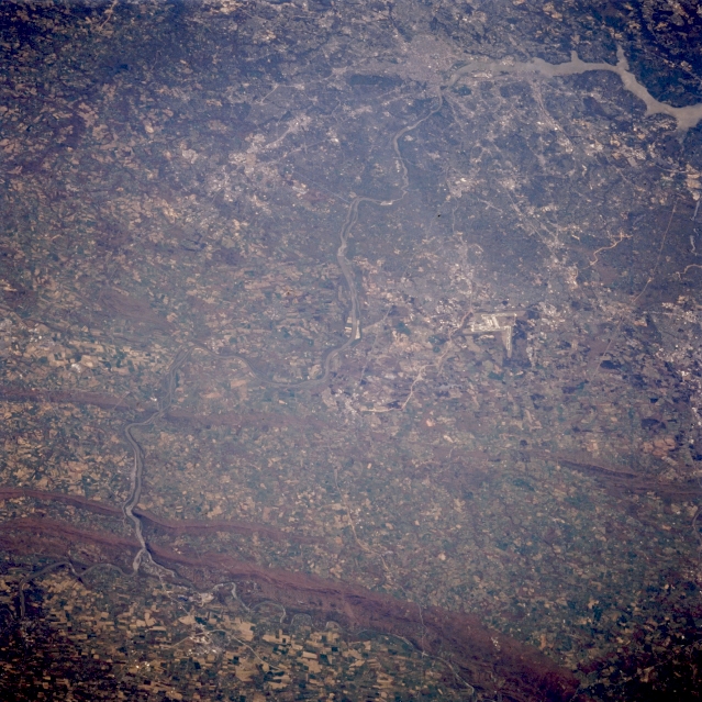 |
| STS059-225-071 Potomac River; The Piedmont, Virginia/Maryland, U.S.A. April 1994 The rolling landscape of the Piedmont Region of Virginia and Maryland can be seen in this southeast-looking low-oblique view. In the upper right portion of the image, the Metropolitan Washington, D.C., area and the tidal estuary of the Potomac River are visible. At the bottom left of the image, a small portion of the Shenandoah River Valley is discernible. The Blue Ridge Mountains cross the bottom portion of the image. The Potomac River, separating Virginia to the right (south), and Maryland to the left (north), is visible traversing the scene near the bottom center of the image. The river cuts gaps into the Blue Ridge Mountains, as it flows generally southeastward into Washington, D.C. The runways of the Dulles International Airport can be seen to the right of the center of the image. |
| Images: | All Available Images Low-Resolution 382k |
|
| Mission: | STS059 |
|
| Roll - Frame: | 225 - 71 |
|
| Geographical Name: | USA-VIRGINIA |
|
| Features: | VIRGINIA, CITIES, RIVERS |
|
| Center Lat x Lon: | 39.0N x 77.5W |
|
| Film Exposure: | N | N=Normal exposure, U=Under exposed, O=Over exposed, F=out of Focus |
| Percentage of Cloud Cover-CLDP: | 0 |
|
| Camera:: | HB |
|
| Camera Tilt: | 51 | LO=Low Oblique, HO=High Oblique, NV=Near Vertical |
| Camera Focal Length: | 250 |
|
| Nadir to Photo Center Direction: | E | The direction from the nadir to the center point, N=North, S=South, E=East, W=West |
| Stereo?: | N | Y=Yes there is an adjacent picture of the same area, N=No there isn't |
| Orbit Number: | 150 |
|
| Date: | 19940418 | YYYYMMDD |
| Time: | 155856 | GMT HHMMSS |
| Nadir Lat: | 40.0N |
Latitude of suborbital point of spacecraft |
| Nadir Lon: | 79.6W |
Longitude of suborbital point of spacecraft |
| Sun Azimuth: | 143 | Clockwise angle in degrees from north to the sun measured at the nadir point |
| Space Craft Altitude: | 113 | nautical miles |
| Sun Elevation: | 56 | Angle in degrees between the horizon and the sun, measured at the nadir point |
| Land Views: | MOUNTAIN, PLAIN, FOREST |
|
| Water Views: | RIVER |
|
| Atmosphere Views: | |
|
| Man Made Views: | URBAN AREA, AIRPORT, AGRICULTURE |
|
| City Views: | |
|
Photo is not associated with any sequences | ||
| NASA Home Page |
JSC Home Page |
JSC Digital Image Collection |
Earth Science & Remote Sensing |
|
This service is provided by the International Space Station program and the JSC Earth Science & Remote Sensing Unit, ARES Division, Exploration Integration Science Directorate.

|