Geographic Region: JAPAN
Feature: PAN- SHIKOKU, S HONSHU
|
Geographic Region: JAPAN Feature: PAN- SHIKOKU, S HONSHU |
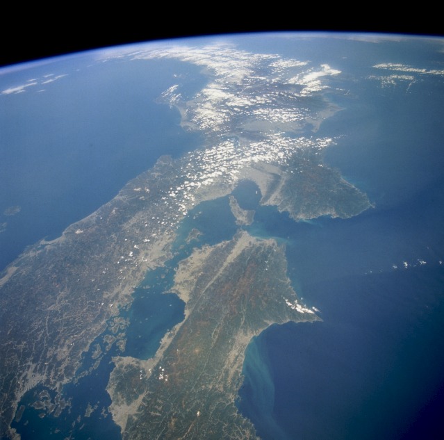 |
| STS059-218-044 Southern Honshu Island and Shikoku Island, Japan April 1994 This high-oblique, northeast-looking photograph captures a portion of the Japanese archipelago. The darker areas show volcanic, mountainous terrain that comprises more than 80 percent of Japan; the lighter, more highly reflective areas of the coastal plains and valleys are urban and agricultural areas. Separated by the Seto Inland Sea are Shikoku Island to the south and the Osaka-Kobe industrial metroplex on Honshu Island to the north. The Sea of Japan lies north of Honshu Island. Several lines, which are northeast-southwest-trending faults, appear on Shikoku Island, extend under the Kii Channel, and continue across southern Honshu Island. This geologically young, earthquake-prone area exists as a result of the collision of the southeast-moving Eurasian Plate and the northwest-moving Philippine Plate. |
| Images: | All Available Images Low-Resolution 88k |
|
| Mission: | STS059 |
|
| Roll - Frame: | 218 - 44 |
|
| Geographical Name: | JAPAN |
|
| Features: | PAN- SHIKOKU, S HONSHU |
|
| Center Lat x Lon: | 34.5N x 135.0E |
|
| Film Exposure: | N | N=Normal exposure, U=Under exposed, O=Over exposed, F=out of Focus |
| Percentage of Cloud Cover-CLDP: | 20 |
|
| Camera:: | HB |
|
| Camera Tilt: | HO | LO=Low Oblique, HO=High Oblique, NV=Near Vertical |
| Camera Focal Length: | 40 |
|
| Nadir to Photo Center Direction: | NE | The direction from the nadir to the center point, N=North, S=South, E=East, W=West |
| Stereo?: | Y | Y=Yes there is an adjacent picture of the same area, N=No there isn't |
| Orbit Number: | 77 |
|
| Date: | 19940414 | YYYYMMDD |
| Time: | 040639 | GMT HHMMSS |
| Nadir Lat: | 32.9N |
Latitude of suborbital point of spacecraft |
| Nadir Lon: | 132.7E |
Longitude of suborbital point of spacecraft |
| Sun Azimuth: | 213 | Clockwise angle in degrees from north to the sun measured at the nadir point |
| Space Craft Altitude: | 117 | nautical miles |
| Sun Elevation: | 63 | Angle in degrees between the horizon and the sun, measured at the nadir point |
| Land Views: | COAST, MOUNTAIN, FAULT, ISLAND, PENINSULA |
|
| Water Views: | SEA, OCEAN, BAY, STRAIT |
|
| Atmosphere Views: | |
|
| Man Made Views: | URBAN AREA, AGRICULTURE |
|
| City Views: | |
|
Photo is not associated with any sequences | ||
| NASA Home Page |
JSC Home Page |
JSC Digital Image Collection |
Earth Science & Remote Sensing |
|
This service is provided by the International Space Station program and the JSC Earth Science & Remote Sensing Unit, ARES Division, Exploration Integration Science Directorate.

|