
Geographic Region: RUSSIAN FEDERATION
Feature: VOLGOGRAD, VOLGA RIVER
|
Geographic Region: RUSSIAN FEDERATION Feature: VOLGOGRAD, VOLGA RIVER |
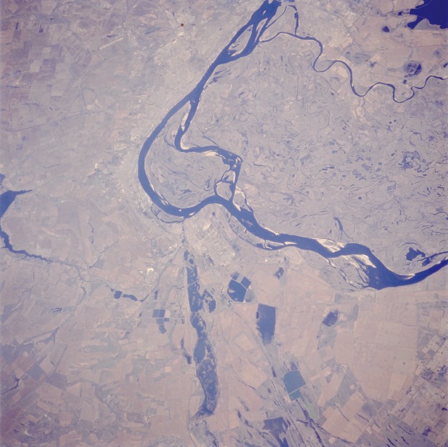 |
| STS059-217-008 Volga River, Volgograd, Russia April 1994 Volgograd, a city of more than 1 million people and a major river port and railroad junction for making connections to all parts of Russia, is located along the western shore of the Volga River. Little of the city's infrastructure is visible in this photograph; however, the following can be seen in the built-up area: two airports, large reservoirs south of the city, the Volga-Don Canal, and some railroad rights-of-way. The Volga-Don Canal is important to the area because it allows waterborne shipping from the Volga River to the Don River, through the Sea of Azov, and into the Black Sea. Despite the fact that this region is a semiarid climate zone [less than 20 inches (50 centimeters) of precipitation annually], it continues to thrive as a manufacturing and industrial center for this part of Russia. The large center island and terrain immediately to the east contain many old stream channels with many small lakes; this marshy area is an extension of the much larger Caspian Depression. Large cultivated field patterns can be seen south and west of Volgograd. |
| Images: | All Available Images Low-Resolution 110k |
|
| Mission: | STS059 |
|
| Roll - Frame: | 217 - 8 |
|
| Geographical Name: | RUSSIAN FEDERATION |
|
| Features: | VOLGOGRAD, VOLGA RIVER |
|
| Center Lat x Lon: | 48.5N x 44.5E |
|
| Film Exposure: | N | N=Normal exposure, U=Under exposed, O=Over exposed, F=out of Focus |
| Percentage of Cloud Cover-CLDP: | 0 |
|
| Camera:: | HB |
|
| Camera Tilt: | 44 | LO=Low Oblique, HO=High Oblique, NV=Near Vertical |
| Camera Focal Length: | 250 |
|
| Nadir to Photo Center Direction: | NW | The direction from the nadir to the center point, N=North, S=South, E=East, W=West |
| Stereo?: | Y | Y=Yes there is an adjacent picture of the same area, N=No there isn't |
| Orbit Number: | 80 |
|
| Date: | 19940414 | YYYYMMDD |
| Time: | 082742 | GMT HHMMSS |
| Nadir Lat: | 47.6N |
Latitude of suborbital point of spacecraft |
| Nadir Lon: | 46.1E |
Longitude of suborbital point of spacecraft |
| Sun Azimuth: | 169 | Clockwise angle in degrees from north to the sun measured at the nadir point |
| Space Craft Altitude: | 116 | nautical miles |
| Sun Elevation: | 52 | Angle in degrees between the horizon and the sun, measured at the nadir point |
| Land Views: | PLAIN |
|
| Water Views: | RIVER |
|
| Atmosphere Views: | |
|
| Man Made Views: | URBAN AREA, AGRICULTURE, DAM, AIRPORT |
|
| City Views: | |
|
Photo is not associated with any sequences | ||
| NASA Home Page |
JSC Home Page |
JSC Digital Image Collection |
Earth Science & Remote Sensing |
|
This service is provided by the International Space Station program and the JSC Earth Science & Remote Sensing Unit, ARES Division, Exploration Integration Science Directorate.

|