
Geographic Region: USA-MARYLAND
Feature: CHINCOTEAGUE BAY AREA
|
Geographic Region: USA-MARYLAND Feature: CHINCOTEAGUE BAY AREA |
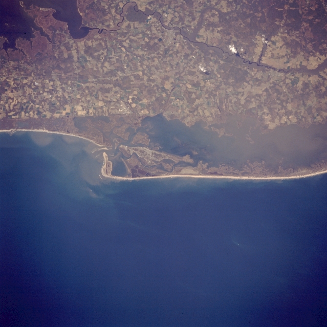 |
| STS059-217-079 ASSATEAGUE ISLAND, CHINCOTEAGUE BAY, MARYLAND/VIRGINIA APRIL, 1993 Assateague Island, a national seashore 37 miles (58 km) long, can be seen in this west-looking low-oblique view. Assateague is a barrier island. A wildlife refuge makes up part of the island and is home to the famed Chincoteague wild ponies. The island is mostly uninhabited by human beings. Near the upper left portion of the image is the Pocomoke River. The mainland area seen in the upper third of the image is part of the Delmarva Peninsula. |
| Images: | All Available Images Low-Resolution 287k |
|
| Mission: | STS059 |
|
| Roll - Frame: | 217 - 79 |
|
| Geographical Name: | USA-MARYLAND |
|
| Features: | CHINCOTEAGUE BAY AREA |
|
| Center Lat x Lon: | 38.0N x 75.5W |
|
| Film Exposure: | N | N=Normal exposure, U=Under exposed, O=Over exposed, F=out of Focus |
| Percentage of Cloud Cover-CLDP: | 0 |
|
| Camera:: | HB |
|
| Camera Tilt: | NV | LO=Low Oblique, HO=High Oblique, NV=Near Vertical |
| Camera Focal Length: | 250 |
|
| Nadir to Photo Center Direction: | NW | The direction from the nadir to the center point, N=North, S=South, E=East, W=West |
| Stereo?: | Y | Y=Yes there is an adjacent picture of the same area, N=No there isn't |
| Orbit Number: | 86 |
|
| Date: | 19940414 | YYYYMMDD |
| Time: | 172400 | GMT HHMMSS |
| Nadir Lat: | 37.2N |
Latitude of suborbital point of spacecraft |
| Nadir Lon: | 74.5W |
Longitude of suborbital point of spacecraft |
| Sun Azimuth: | 193 | Clockwise angle in degrees from north to the sun measured at the nadir point |
| Space Craft Altitude: | 115 | nautical miles |
| Sun Elevation: | 62 | Angle in degrees between the horizon and the sun, measured at the nadir point |
| Land Views: | COAST, ISLAND |
|
| Water Views: | LAGOON |
|
| Atmosphere Views: | |
|
| Man Made Views: | AGRICULTURE |
|
| City Views: | |
|
Photo is not associated with any sequences | ||
| NASA Home Page |
JSC Home Page |
JSC Digital Image Collection |
Earth Science & Remote Sensing |
|
This service is provided by the International Space Station program and the JSC Earth Science & Remote Sensing Unit, ARES Division, Exploration Integration Science Directorate.

|