
Geographic Region: USA-PENNSYLVANIA
Feature: HARRISBURG,SUSQUEHANNA R
|
Geographic Region: USA-PENNSYLVANIA Feature: HARRISBURG,SUSQUEHANNA R |
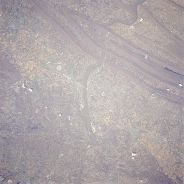 |
| STS059-217-073 Greater Harrisburg Area, Pennsylvania, U.S.A. April 1994 The greater Harrisburg area is shown in this near-vertical photograph. Major physical features include a small section of the folded Appalachian Mountains with the paralleling ridge and valley pattern, the southward-flowing Susquehanna River, the rolling hills and fertile valleys surrounding the capital city, and water gaps created by the Susquehanna River as it cuts through the mountains north of Harrisburg. Several manmade features appear in this fairly detailed photograph of the Cumberland Valley (west of the Susquehanna River) and Dauphin County (east of the Susquehanna River). Visible are some highway bridges that cross the Susquehanna River and connect Harrisburg with towns on the west shore (Enola, New Cumberland, Camp Hill, and Mechanicsburg). Famous Three Mile Island in the Susquehanna River can be seen south of Harrisburg International Airport (formerly Olmsted Air Force Base). An extensive ground transportation network, including Interstate Highways 81 and 83 and the Pennsylvania Turnpike, traverses the region, linking the large east coast population with that of the midwest and southwest states. The large white block west-northwest of Harrisburg is the U.S. Navy storage depot near Mechanicsburg. Chocolate Town-USA (Hershey, Pennsylvania) is barely recognizable 12 miles (19 kilometers) east of Harrisburg as one in a string of towns. Cultivated fields of crops used primarily for beef cattle and dairy cattle feed dominate the rural scene. (Refer to STS-059-205-067 for a synoptic view that includes the northern half of this photograph.) |
| Images: | All Available Images Low-Resolution 111k |
|
| Mission: | STS059 |
|
| Roll - Frame: | 217 - 73 |
|
| Geographical Name: | USA-PENNSYLVANIA |
|
| Features: | HARRISBURG,SUSQUEHANNA R |
|
| Center Lat x Lon: | 40.5N x 77W |
|
| Film Exposure: | N | N=Normal exposure, U=Under exposed, O=Over exposed, F=out of Focus |
| Percentage of Cloud Cover-CLDP: | 0 |
|
| Camera:: | HB |
|
| Camera Tilt: | 30 | LO=Low Oblique, HO=High Oblique, NV=Near Vertical |
| Camera Focal Length: | 250 |
|
| Nadir to Photo Center Direction: | N | The direction from the nadir to the center point, N=North, S=South, E=East, W=West |
| Stereo?: | Y | Y=Yes there is an adjacent picture of the same area, N=No there isn't |
| Orbit Number: | 86 |
|
| Date: | 19940414 | YYYYMMDD |
| Time: | 172315 | GMT HHMMSS |
| Nadir Lat: | 39.4N |
Latitude of suborbital point of spacecraft |
| Nadir Lon: | 77W |
Longitude of suborbital point of spacecraft |
| Sun Azimuth: | 187 | Clockwise angle in degrees from north to the sun measured at the nadir point |
| Space Craft Altitude: | 115 | nautical miles |
| Sun Elevation: | 60 | Angle in degrees between the horizon and the sun, measured at the nadir point |
| Land Views: | MOUNTAIN, VALLEY |
|
| Water Views: | RIVER |
|
| Atmosphere Views: | |
|
| Man Made Views: | URBAN AREA, AGRICULTURE |
|
| City Views: | HARRISBURG |
|
Photo is not associated with any sequences | ||
| NASA Home Page |
JSC Home Page |
JSC Digital Image Collection |
Earth Science & Remote Sensing |
|
This service is provided by the International Space Station program and the JSC Earth Science & Remote Sensing Unit, ARES Division, Exploration Integration Science Directorate.

|