Geographic Region: CANADA-NS
Feature: CHEDOBUCTO BAY AREA
|
Geographic Region: CANADA-NS Feature: CHEDOBUCTO BAY AREA |
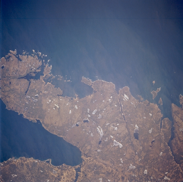 |
| STS059-216-078 Chedabucto Bay, Nova Scotia, Canada April 1994 Most of the land shown in this picture is an easterly pointing peninsula that is located between the Atlantic Ocean (top) and the Chedabucto Bay (lower left). Numerous lakes, varying in size, are scattered across the landscape. Many are still covered with ice (whitish looking features); while a few lakes (darker, irregular shaped features) show open water. |
| Images: | All Available Images Low-Resolution 297k |
|
| Mission: | STS059 |
|
| Roll - Frame: | 216 - 78 |
|
| Geographical Name: | CANADA-NS |
|
| Features: | CHEDOBUCTO BAY AREA |
|
| Center Lat x Lon: | 45.0N x 61.5W |
|
| Film Exposure: | N | N=Normal exposure, U=Under exposed, O=Over exposed, F=out of Focus |
| Percentage of Cloud Cover-CLDP: | 0 |
|
| Camera:: | HB |
|
| Camera Tilt: | 25 | LO=Low Oblique, HO=High Oblique, NV=Near Vertical |
| Camera Focal Length: | 250 |
|
| Nadir to Photo Center Direction: | W | The direction from the nadir to the center point, N=North, S=South, E=East, W=West |
| Stereo?: | N | Y=Yes there is an adjacent picture of the same area, N=No there isn't |
| Orbit Number: | 53 |
|
| Date: | 19940412 | YYYYMMDD |
| Time: | 163138 | GMT HHMMSS |
| Nadir Lat: | 45.1N |
Latitude of suborbital point of spacecraft |
| Nadir Lon: | 60.6W |
Longitude of suborbital point of spacecraft |
| Sun Azimuth: | 192 | Clockwise angle in degrees from north to the sun measured at the nadir point |
| Space Craft Altitude: | 117 | nautical miles |
| Sun Elevation: | 53 | Angle in degrees between the horizon and the sun, measured at the nadir point |
| Land Views: | HILL |
|
| Water Views: | BAY, LAKE |
|
| Atmosphere Views: | |
|
| Man Made Views: | |
|
| City Views: | |
|
Photo is not associated with any sequences | ||
| NASA Home Page |
JSC Home Page |
JSC Digital Image Collection |
Earth Science & Remote Sensing |
|
This service is provided by the International Space Station program and the JSC Earth Science & Remote Sensing Unit, ARES Division, Exploration Integration Science Directorate.

|