
Geographic Region: IRAQ
Feature: BAGHDAD
|
Geographic Region: IRAQ Feature: BAGHDAD |
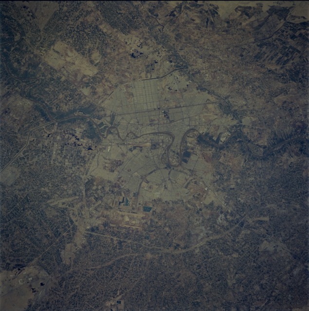 |
| STS059-211-058 Baghdad, Iraq April 1994 Baghdad, the capital of Iraq with a population of almost 2 300 000, is featured in this near-vertical photograph. Located in central Iraq on both banks of the Tigris River and near the northern end of the floodplain of the Euphrates and Tigris Rivers, Baghdad is the commercial and transportation center of the country. Major industries include railroad workshops; chemical refineries; and the making of carpets, leather, textiles, cement, and tobacco products. Although situated in a semiarid region, the city is surrounded by agricultural fields that are irrigated by both the Tigris River and the Euphrates River, which flows 18 miles (30 kilometers) west of the central city. Baghdad, with its rich history, numerous archaeological sites, and many museums, is still recovering from the results of the Gulf War of early 1991 and the sanctions imposed on the country by the United Nations because of that war. |
| Images: | All Available Images Low-Resolution 135k |
|
| Mission: | STS059 |
|
| Roll - Frame: | 211 - 58 |
|
| Geographical Name: | IRAQ |
|
| Features: | BAGHDAD |
|
| Center Lat x Lon: | 33.5N x 44.5E |
|
| Film Exposure: | N | N=Normal exposure, U=Under exposed, O=Over exposed, F=out of Focus |
| Percentage of Cloud Cover-CLDP: | 0 |
|
| Camera:: | HB |
|
| Camera Tilt: | 33 | LO=Low Oblique, HO=High Oblique, NV=Near Vertical |
| Camera Focal Length: | 250 |
|
| Nadir to Photo Center Direction: | NE | The direction from the nadir to the center point, N=North, S=South, E=East, W=West |
| Stereo?: | Y | Y=Yes there is an adjacent picture of the same area, N=No there isn't |
| Orbit Number: | 65 |
|
| Date: | 19940413 | YYYYMMDD |
| Time: | 102122 | GMT HHMMSS |
| Nadir Lat: | 32.7N |
Latitude of suborbital point of spacecraft |
| Nadir Lon: | 43.5E |
Longitude of suborbital point of spacecraft |
| Sun Azimuth: | 221 | Clockwise angle in degrees from north to the sun measured at the nadir point |
| Space Craft Altitude: | 117 | nautical miles |
| Sun Elevation: | 61 | Angle in degrees between the horizon and the sun, measured at the nadir point |
| Land Views: | DESERT, VALLEY |
|
| Water Views: | RIVER |
|
| Atmosphere Views: | |
|
| Man Made Views: | URBAN AREA, AGRICULTURE, AIRPORT |
|
| City Views: | BAGHDAD |
|
Photo is not associated with any sequences | ||
| NASA Home Page |
JSC Home Page |
JSC Digital Image Collection |
Earth Science & Remote Sensing |
|
This service is provided by the International Space Station program and the JSC Earth Science & Remote Sensing Unit, ARES Division, Exploration Integration Science Directorate.

|