Geographic Region: PACIFIC OCEAN I(S).
Feature: IWO JIMA
|
Geographic Region: PACIFIC OCEAN I(S). Feature: IWO JIMA |
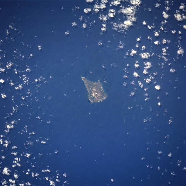 |
| STS059-210-033 Iwo Jima, Volcano Islands April 1994 The largest of three Volcano Islands, Iwo Jima can be seen in this south-looking view. Iwo Jima is nearly 5 miles (9km) long, and 2 miles (4 km) wide and covers an area of 8 sq. miles (21 sq. km). Mount Suribachi, 546 feet (167 meters) high, on the south side of the island, is an extinct volcano. The main industries are sulfur mining and sugar refining. Iwo Jima was the scene for one of the severest battle campaigns in United States history during World War II. The battle began on February 19, 1945 against a Japanese force of over 22000 troops, who were well fortified in the numerous caves that make up the island topography. Casualties were high on both sides. The island was completely taken by United States forces on March 15, 1945. The photograph acquired of the United States flag being raised by U.S. Marines on the top of Mount Suribachi is one of the most famous photographs ever taken and inspired a memorial being built near Washington, D.C. honoring the United Stated Marine Corps. |
| Images: | All Available Images Low-Resolution 314k |
|
| Mission: | STS059 |
|
| Roll - Frame: | 210 - 33 |
|
| Geographical Name: | PACIFIC OCEAN I(S). |
|
| Features: | IWO JIMA |
|
| Center Lat x Lon: | 25.0N x 141.0E |
|
| Film Exposure: | N | N=Normal exposure, U=Under exposed, O=Over exposed, F=out of Focus |
| Percentage of Cloud Cover-CLDP: | 5 |
|
| Camera:: | HB |
|
| Camera Tilt: | 3 | LO=Low Oblique, HO=High Oblique, NV=Near Vertical |
| Camera Focal Length: | 250 |
|
| Nadir to Photo Center Direction: | S | The direction from the nadir to the center point, N=North, S=South, E=East, W=West |
| Stereo?: | Y | Y=Yes there is an adjacent picture of the same area, N=No there isn't |
| Orbit Number: | 45 |
|
| Date: | 19940412 | YYYYMMDD |
| Time: | 044751 | GMT HHMMSS |
| Nadir Lat: | 25.1N |
Latitude of suborbital point of spacecraft |
| Nadir Lon: | 141.0E |
Longitude of suborbital point of spacecraft |
| Sun Azimuth: | 248 | Clockwise angle in degrees from north to the sun measured at the nadir point |
| Space Craft Altitude: | 120 | nautical miles |
| Sun Elevation: | 55 | Angle in degrees between the horizon and the sun, measured at the nadir point |
| Land Views: | ISLAND, VOLCANO |
|
| Water Views: | OCEAN |
|
| Atmosphere Views: | |
|
| Man Made Views: | AIRPORT |
|
| City Views: | |
|
Photo is not associated with any sequences | ||
| NASA Home Page |
JSC Home Page |
JSC Digital Image Collection |
Earth Science & Remote Sensing |
|
This service is provided by the International Space Station program and the JSC Earth Science & Remote Sensing Unit, ARES Division, Exploration Integration Science Directorate.

|