Geographic Region: RUSSIAN FEDERATION
Feature: OMSK
|
Geographic Region: RUSSIAN FEDERATION Feature: OMSK |
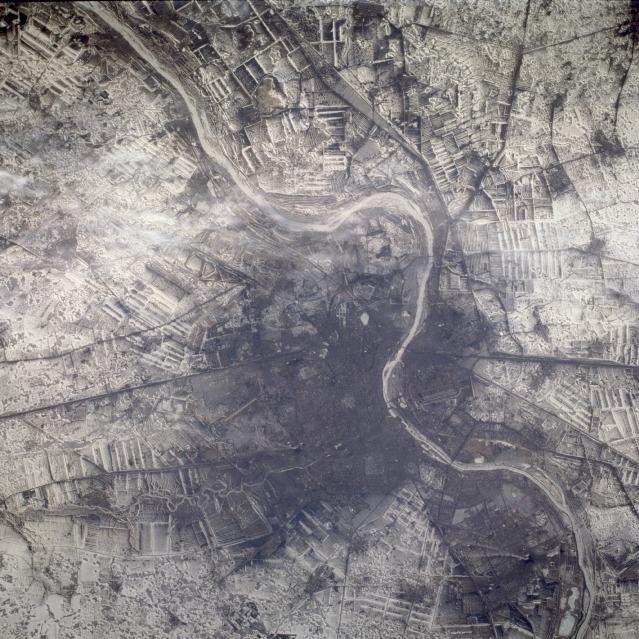 |
| STS059-210-011 Omsk, Russia April 1994 The Russian city of Omsk, with a population of more than 1 million, is located on the southern boundary of the western Siberian lowlands. This photograph, taken with snow covering most of the landscape, shows large cultivated field patterns of spring wheat surrounding the city. Omsk is a major river port on the Irtysh River, which flows south to north. Located in the city are oil refineries, grain mills, textile plants, and manufacturing centers for agricultural machinery and railroad equipment. Omsk is a major ground transportation hub for the region. The Trans-Siberian railroad that extends from Moscow to Vladivostok is visible running east-west through the downtown area, and other railroads and highways are seen radiating outward from downtown Omsk. The dark area of the central city is probably caused by either the "heat island" effect of the city or by burning fossil fuels in homes and factories, resulting in air pollution. |
| Images: | All Available Images Low-Resolution 180k |
|
| Mission: | STS059 |
|
| Roll - Frame: | 210 - 11 |
|
| Geographical Name: | RUSSIAN FEDERATION |
|
| Features: | OMSK |
|
| Center Lat x Lon: | 55.0N x 73.5E |
|
| Film Exposure: | N | N=Normal exposure, U=Under exposed, O=Over exposed, F=out of Focus |
| Percentage of Cloud Cover-CLDP: | 0 |
|
| Camera:: | HB |
|
| Camera Tilt: | 13 | LO=Low Oblique, HO=High Oblique, NV=Near Vertical |
| Camera Focal Length: | 250 |
|
| Nadir to Photo Center Direction: | SW | The direction from the nadir to the center point, N=North, S=South, E=East, W=West |
| Stereo?: | N | Y=Yes there is an adjacent picture of the same area, N=No there isn't |
| Orbit Number: | 44 |
|
| Date: | 19940412 | YYYYMMDD |
| Time: | 030113 | GMT HHMMSS |
| Nadir Lat: | 55.2N |
Latitude of suborbital point of spacecraft |
| Nadir Lon: | 73.9E |
Longitude of suborbital point of spacecraft |
| Sun Azimuth: | 110 | Clockwise angle in degrees from north to the sun measured at the nadir point |
| Space Craft Altitude: | 117 | nautical miles |
| Sun Elevation: | 23 | Angle in degrees between the horizon and the sun, measured at the nadir point |
| Land Views: | |
|
| Water Views: | RIVER |
|
| Atmosphere Views: | PLUME |
|
| Man Made Views: | URBAN AREA, POLLUTION |
|
| City Views: | OMSK |
|
Photo is not associated with any sequences | ||
| NASA Home Page |
JSC Home Page |
JSC Digital Image Collection |
Earth Science & Remote Sensing |
|
This service is provided by the International Space Station program and the JSC Earth Science & Remote Sensing Unit, ARES Division, Exploration Integration Science Directorate.

|