
Geographic Region: USA-PENNSYLVANIA
Feature: L. ERIE & CHAUTAUQUA
|
Geographic Region: USA-PENNSYLVANIA Feature: L. ERIE & CHAUTAUQUA |
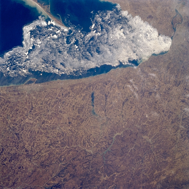 |
| STS059-205-065 Lake Erie Ice Flow, Ohio April 1993 Ice flows are visible along the eastern shore of Lake Erie in this north-looking view. Lake Erie is 241 miles (388 km) long and from 30 to 57 miles (48 to 92 km) wide. Lake Erie is the forth largest and shallowest of the five Great lakes with a maximum depth of 210 feet (64 meters), and is the only Great Lake with its lake floor above sea level. Lake Erie is partially ice bound in winter and is normally closed to ship traffic from mid-December to the end of March. As the ice begins to break up in March, predominantly westerly winds push the ice eastward toward Buffalo, New York (top right of image). The city of Erie, Pennsylvania can be seen near the left center of the image on the southern shore of Lake Erie. Presque Isle, a peninsula, is discernible protruding out into Lake Erie. This peninsula helps form Erie's superb harbor, Pennsylvania's only Great Lakes port. Portions of the dissected Allegheny Plateau can be seen covering the lower right quadrant of the image. Near the center of the image, the bluish-colored waters of Chautauqua Lake are discernible. To the south of Chautauqua Lake are sediment-laden waters of the Allegheny Reservoir. |
| Images: | All Available Images Low-Resolution 386k |
|
| Mission: | STS059 |
|
| Roll - Frame: | 205 - 65 |
|
| Geographical Name: | USA-PENNSYLVANIA |
|
| Features: | L. ERIE & CHAUTAUQUA |
|
| Center Lat x Lon: | 42.0N x 79W |
|
| Film Exposure: | N | N=Normal exposure, U=Under exposed, O=Over exposed, F=out of Focus |
| Percentage of Cloud Cover-CLDP: | 0 |
|
| Camera:: | HB |
|
| Camera Tilt: | 53 | LO=Low Oblique, HO=High Oblique, NV=Near Vertical |
| Camera Focal Length: | 100 |
|
| Nadir to Photo Center Direction: | E | The direction from the nadir to the center point, N=North, S=South, E=East, W=West |
| Stereo?: | N | Y=Yes there is an adjacent picture of the same area, N=No there isn't |
| Orbit Number: | 102 |
|
| Date: | 19940415 | YYYYMMDD |
| Time: | 170140 | GMT HHMMSS |
| Nadir Lat: | 42.4N |
Latitude of suborbital point of spacecraft |
| Nadir Lon: | 81.5W |
Longitude of suborbital point of spacecraft |
| Sun Azimuth: | 169 | Clockwise angle in degrees from north to the sun measured at the nadir point |
| Space Craft Altitude: | 114 | nautical miles |
| Sun Elevation: | 57 | Angle in degrees between the horizon and the sun, measured at the nadir point |
| Land Views: | PLATEAU, FOREST, PLAIN |
|
| Water Views: | LAKE, SEA ICE |
|
| Atmosphere Views: | |
|
| Man Made Views: | URBAN AREA, AGRICULTURE |
|
| City Views: | |
|
Photo is not associated with any sequences | ||
| NASA Home Page |
JSC Home Page |
JSC Digital Image Collection |
Earth Science & Remote Sensing |
|
This service is provided by the International Space Station program and the JSC Earth Science & Remote Sensing Unit, ARES Division, Exploration Integration Science Directorate.

|