
Geographic Region: AUSTRALIA-WA
Feature: KING SOUND,BUCCANEER ARC
|
Geographic Region: AUSTRALIA-WA Feature: KING SOUND,BUCCANEER ARC |
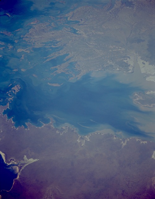 |
| STS059-157-092 King Sound, Western Australia April 1994 The blue, sediment-filled waters of King Sound on the northwest Australian coast are the centerpiece of this low-oblique, east-looking photograph. An inlet of the Timor Sea, King Sound is fed by many streams and rivers, the major one being the Fitzroy (not visible in the photograph), which brings sediment from the Kimberley Plateau nearly 100 miles (62 kilometers) inland. Northwest of King Sound, a portion of Pender Bay is visible. East of King Sound are the rugged, folded, and faulted highlands of the Wyndham Range and its many finger-like points extending into the sea. The ancient rocks of the Wyndham Range and the Kimberley Plateau are believed to be the edge of a great shield that once linked other continents such as India, Africa, South America, and Antarctica in a giant landmass. Because of the rising ocean levels during the last 12 000 years in this area, the former coastline around the sound has submerged. The King Sound region has the world's most dangerous calm-weather coast, with tides that can rise to nearly 40 feet (12 meters). Racing in and out of inlets surrounded by cliffs (east-northeast of the sound), the tides can set up eddying currents that boil around craggy islands and over coral reefs. |
| Images: | All Available Images Low-Resolution 63k |
|
| Mission: | STS059 |
|
| Roll - Frame: | 157 - 92 |
|
| Geographical Name: | AUSTRALIA-WA |
|
| Features: | KING SOUND,BUCCANEER ARC |
|
| Center Lat x Lon: | 16.5S x 123.5E |
|
| Film Exposure: | N | N=Normal exposure, U=Under exposed, O=Over exposed, F=out of Focus |
| Percentage of Cloud Cover-CLDP: | 0 |
|
| Camera:: | LH |
|
| Camera Tilt: | LO | LO=Low Oblique, HO=High Oblique, NV=Near Vertical |
| Camera Focal Length: | 250 |
|
| Nadir to Photo Center Direction: | The direction from the nadir to the center point, N=North, S=South, E=East, W=West |
|
| Stereo?: | N | Y=Yes there is an adjacent picture of the same area, N=No there isn't |
| Orbit Number: | |
|
| Date: | 199404__ | YYYYMMDD |
| Time: | GMT HHMMSS |
|
| Nadir Lat: | N |
Latitude of suborbital point of spacecraft |
| Nadir Lon: | E |
Longitude of suborbital point of spacecraft |
| Sun Azimuth: | Clockwise angle in degrees from north to the sun measured at the nadir point |
|
| Space Craft Altitude: | nautical miles |
|
| Sun Elevation: | Angle in degrees between the horizon and the sun, measured at the nadir point |
|
| Land Views: | HILL, FAULT |
|
| Water Views: | BAY, SEDIMENT, INLET |
|
| Atmosphere Views: | |
|
| Man Made Views: | |
|
| City Views: | |
|
Photo is not associated with any sequences | ||
| NASA Home Page |
JSC Home Page |
JSC Digital Image Collection |
Earth Science & Remote Sensing |
|
This service is provided by the International Space Station program and the JSC Earth Science & Remote Sensing Unit, ARES Division, Exploration Integration Science Directorate.

|