
Geographic Region: USA-CALIFORNIA
Feature: MOJAVE DES,SALT PANS,MTS
|
Geographic Region: USA-CALIFORNIA Feature: MOJAVE DES,SALT PANS,MTS |
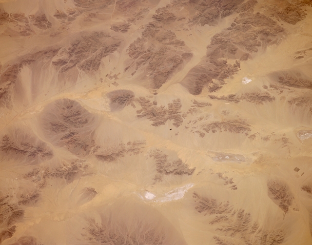 |
| STS059-154-167 Joshua Tree National Monument, Southern California, U.S.A. April 1994 Few signs of human activity appear in this desert photograph of southeastern California. Recognizing and mapping various dry lakebeds with their highly reflective surfaces and dark, small mountains provide the only method for navigation through such landscapes. The section of Interstate Highway 10 that connects Blythe and Indio, California, is visible as a thin, dark line in the upper left section of the photograph. A few isolated, rectangular field patterns are discernible north of the highway and west of Palen Lake, a dry lakebed. This is also the approximate location of Desert Center, a very small desert town. Several rectangular fields and a thin line, which is probably a railroad right-of-way, indicate the approximate location of Cadiz, another small desert town north of Desert Center, near the lower right edge of the photograph. |
| Images: | All Available Images Low-Resolution 214k |
|
| Mission: | STS059 |
|
| Roll - Frame: | 154 - 167 |
|
| Geographical Name: | USA-CALIFORNIA |
|
| Features: | MOJAVE DES,SALT PANS,MTS |
|
| Center Lat x Lon: | 34.0N x 115.5W |
|
| Film Exposure: | N | N=Normal exposure, U=Under exposed, O=Over exposed, F=out of Focus |
| Percentage of Cloud Cover-CLDP: | 0 |
|
| Camera:: | LH |
|
| Camera Tilt: | 34 | LO=Low Oblique, HO=High Oblique, NV=Near Vertical |
| Camera Focal Length: | 250 |
|
| Nadir to Photo Center Direction: | SW | The direction from the nadir to the center point, N=North, S=South, E=East, W=West |
| Stereo?: | Y | Y=Yes there is an adjacent picture of the same area, N=No there isn't |
| Orbit Number: | 40 |
|
| Date: | 19940411 | YYYYMMDD |
| Time: | 212038 | GMT HHMMSS |
| Nadir Lat: | 34.8N |
Latitude of suborbital point of spacecraft |
| Nadir Lon: | 114.4W |
Longitude of suborbital point of spacecraft |
| Sun Azimuth: | 228 | Clockwise angle in degrees from north to the sun measured at the nadir point |
| Space Craft Altitude: | 119 | nautical miles |
| Sun Elevation: | 55 | Angle in degrees between the horizon and the sun, measured at the nadir point |
| Land Views: | DESERT, VOLCANO |
|
| Water Views: | PLAYA |
|
| Atmosphere Views: | |
|
| Man Made Views: | |
|
| City Views: | |
|
Photo is not associated with any sequences | ||
| NASA Home Page |
JSC Home Page |
JSC Digital Image Collection |
Earth Science & Remote Sensing |
|
This service is provided by the International Space Station program and the JSC Earth Science & Remote Sensing Unit, ARES Division, Exploration Integration Science Directorate.

|