
Geographic Region: USA-CALIFORNIA
Feature: KINAS R,SIERRA NEVADA,V.
|
Geographic Region: USA-CALIFORNIA Feature: KINAS R,SIERRA NEVADA,V. |
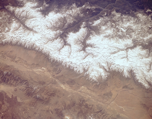 |
| STS059-154-161 Kings River, Owens River, and Sierra Nevada Mountains, California, U.S.A. April 1994 The snow-covered Sierra Nevada Mountains are featured in this low-oblique, south-looking photograph. Two major national parks are visible--Kings Canyon National Park near the center and Sequoia National Park to the south from which the Kern River Canyon extends southward. The three branches of Kings River in Kings Canyon National Park join to form the main branch of the Kings River, which flows west toward the San Joaquin Valley. Between the upper Kern River and the southern fork of the Kings River is Mount Whitney [14 494 feet (4421 meters)], the highest peak in the Sierra Nevadas and the second highest peak in the United States. Apparent north to south along the bottom third of the photograph are the Owens River Valley and to its east the Inyo Mountains. |
| Images: | All Available Images Low-Resolution 280k |
|
| Mission: | STS059 |
|
| Roll - Frame: | 154 - 161 |
|
| Geographical Name: | USA-CALIFORNIA |
|
| Features: | KINAS R,SIERRA NEVADA,V. |
|
| Center Lat x Lon: | 37.0N x 118.5W |
|
| Film Exposure: | N | N=Normal exposure, U=Under exposed, O=Over exposed, F=out of Focus |
| Percentage of Cloud Cover-CLDP: | 5 |
|
| Camera:: | LH |
|
| Camera Tilt: | NV | LO=Low Oblique, HO=High Oblique, NV=Near Vertical |
| Camera Focal Length: | 250 |
|
| Nadir to Photo Center Direction: | SW | The direction from the nadir to the center point, N=North, S=South, E=East, W=West |
| Stereo?: | Y | Y=Yes there is an adjacent picture of the same area, N=No there isn't |
| Orbit Number: | 40 |
|
| Date: | 19940411 | YYYYMMDD |
| Time: | 211937 | GMT HHMMSS |
| Nadir Lat: | 37.8N |
Latitude of suborbital point of spacecraft |
| Nadir Lon: | 117.6W |
Longitude of suborbital point of spacecraft |
| Sun Azimuth: | 220 | Clockwise angle in degrees from north to the sun measured at the nadir point |
| Space Craft Altitude: | 119 | nautical miles |
| Sun Elevation: | 55 | Angle in degrees between the horizon and the sun, measured at the nadir point |
| Land Views: | MOUNTAIN, FAULT |
|
| Water Views: | RIVER |
|
| Atmosphere Views: | |
|
| Man Made Views: | |
|
| City Views: | |
|
Photo is not associated with any sequences | ||
| NASA Home Page |
JSC Home Page |
JSC Digital Image Collection |
Earth Science & Remote Sensing |
|
This service is provided by the International Space Station program and the JSC Earth Science & Remote Sensing Unit, ARES Division, Exploration Integration Science Directorate.

|