
Geographic Region: USA-TENNESSEE
Feature: MEMPHIS, MISS. R., AGRICULTURE
|
Geographic Region: USA-TENNESSEE Feature: MEMPHIS, MISS. R., AGRICULTURE |
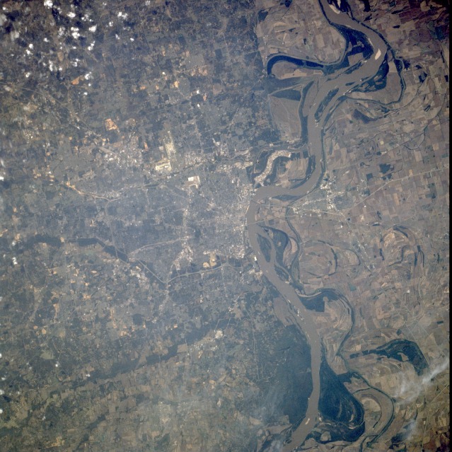 |
| STS058-098-035 Memphis, Tennessee, U.S.A. October 1993 Memphis, located on Chickasaw Bluff on the east bank of the Mississippi River at the mouth of the Wolf River, is the highlight of this near-vertical photograph. Memphis is an important river port; major rail center; and a leading hardwood lumber, cotton, poultry, and livestock market. Other manufacturing industries include pharmaceuticals, textiles, rubber products, furniture, heating and cooling equipment, chemicals, pianos, agricultural machinery, and automobile and truck parts. Memphis, named by Andrew Jackson, is the seat of a large medical center and home to the St. Jude Children's Research Hospital. Numerous agricultural fields are visible west of the Mississippi River in eastern Arkansas. Along with the Mississippi River paddle boats, a leading tourist attraction, the city is home to Beale Street and its music made famous by W. C. Handy, the black American blues composer and compiler. Because heat and humidity provide ideal conditions for mosquitoes, the city suffered from severe yellow fever epidemics in 1867, 1873, and 1878. The runways of Memphis International Airport south of downtown and the runways of the U.S. Naval Air Station at Millington north-northeast of Memphis are discernible. Many small islands, sandbars, and oxbow lakes are obvious in and near the Mississippi River. |
| Images: | All Available Images Low-Resolution 150k |
|
| Mission: | STS058 |
|
| Roll - Frame: | 98 - 35 |
|
| Geographical Name: | USA-TENNESSEE |
|
| Features: | MEMPHIS, MISS. R., AGRICULTURE |
|
| Center Lat x Lon: | 35.0N x 90W |
|
| Film Exposure: | N | N=Normal exposure, U=Under exposed, O=Over exposed, F=out of Focus |
| Percentage of Cloud Cover-CLDP: | 5 |
|
| Camera:: | HB |
|
| Camera Tilt: | 5 | LO=Low Oblique, HO=High Oblique, NV=Near Vertical |
| Camera Focal Length: | 250 |
|
| Nadir to Photo Center Direction: | E | The direction from the nadir to the center point, N=North, S=South, E=East, W=West |
| Stereo?: | Y | Y=Yes there is an adjacent picture of the same area, N=No there isn't |
| Orbit Number: | 130 |
|
| Date: | 19931026 | YYYYMMDD |
| Time: | 164442 | GMT HHMMSS |
| Nadir Lat: | 35.0N |
Latitude of suborbital point of spacecraft |
| Nadir Lon: | 90.2W |
Longitude of suborbital point of spacecraft |
| Sun Azimuth: | 161 | Clockwise angle in degrees from north to the sun measured at the nadir point |
| Space Craft Altitude: | 143 | nautical miles |
| Sun Elevation: | 40 | Angle in degrees between the horizon and the sun, measured at the nadir point |
| Land Views: | PLAIN, HILL, ESCARPMENT, FOREST |
|
| Water Views: | RIVER, SWAMP |
|
| Atmosphere Views: | |
|
| Man Made Views: | URBAN AREA, AIRPORT, AGRICULTURE |
|
| City Views: | MEMPHIS |
|
Photo is not associated with any sequences | ||
| NASA Home Page |
JSC Home Page |
JSC Digital Image Collection |
Earth Science & Remote Sensing |
|
This service is provided by the International Space Station program and the JSC Earth Science & Remote Sensing Unit, ARES Division, Exploration Integration Science Directorate.

|