
Geographic Region: USA-TEXAS
Feature: ABILENE
|
Geographic Region: USA-TEXAS Feature: ABILENE |
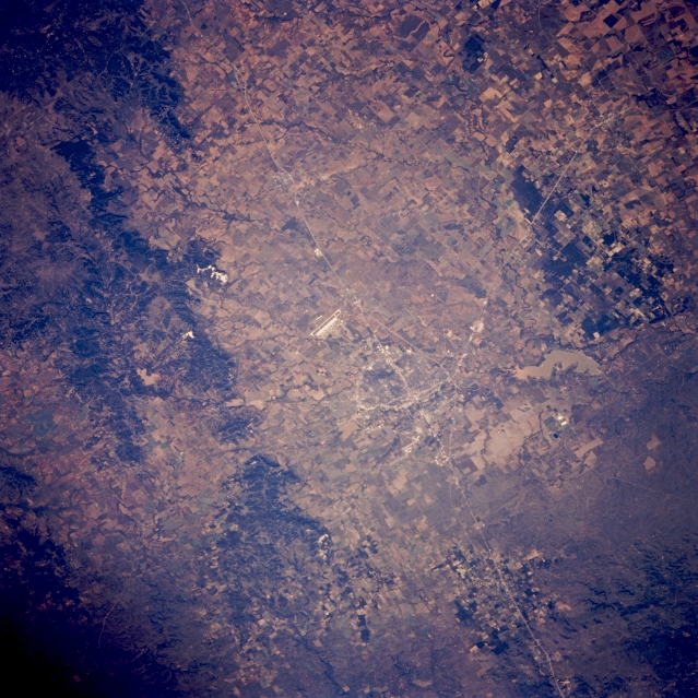 |
| STS058-094-098 Abilene, Texas, U.S.A. October 1993 Discernible in this photograph is east-west-oriented Interstate Highway 20 traversing a relatively flat section of the Permian Basin, looping around the northern edge of Abilene, and intersecting with combined Texas Highways 83 and 277, which connect Abilene with Anson to the northwest. South of Interstate Highway 20 and southwest of Abilene is Dyess Air Force Base with its highly reflective runway and apron (center of photograph). Visible are muddy Lake Fort Phantom Hill north of Abilene and, to the south, the Callahan Divide, a series of generally east-west-trending, vegetated limestone ridges that divert streams north of the divide into the Brazos River and streams south of the divide into the Colorado River Basin. |
| Images: | All Available Images Low-Resolution 390k |
|
| Mission: | STS058 |
|
| Roll - Frame: | 94 - 98 |
|
| Geographical Name: | USA-TEXAS |
|
| Features: | ABILENE |
|
| Center Lat x Lon: | 32.5N x 99.5W |
|
| Film Exposure: | N | N=Normal exposure, U=Under exposed, O=Over exposed, F=out of Focus |
| Percentage of Cloud Cover-CLDP: | 0 |
|
| Camera:: | HB |
|
| Camera Tilt: | 31 | LO=Low Oblique, HO=High Oblique, NV=Near Vertical |
| Camera Focal Length: | 250 |
|
| Nadir to Photo Center Direction: | SE | The direction from the nadir to the center point, N=North, S=South, E=East, W=West |
| Stereo?: | N | Y=Yes there is an adjacent picture of the same area, N=No there isn't |
| Orbit Number: | 65 |
|
| Date: | 19931022 | YYYYMMDD |
| Time: | 150628 | GMT HHMMSS |
| Nadir Lat: | 33.5N |
Latitude of suborbital point of spacecraft |
| Nadir Lon: | 100.7W |
Longitude of suborbital point of spacecraft |
| Sun Azimuth: | 124 | Clockwise angle in degrees from north to the sun measured at the nadir point |
| Space Craft Altitude: | 154 | nautical miles |
| Sun Elevation: | 25 | Angle in degrees between the horizon and the sun, measured at the nadir point |
| Land Views: | RANGE, PLAIN |
|
| Water Views: | RESERVOIR |
|
| Atmosphere Views: | |
|
| Man Made Views: | URBAN AREA, HIGHWAY, AIRPORT |
|
| City Views: | ABILENE |
|
Photo is not associated with any sequences | ||
| NASA Home Page |
JSC Home Page |
JSC Digital Image Collection |
Earth Science & Remote Sensing |
|
This service is provided by the International Space Station program and the JSC Earth Science & Remote Sensing Unit, ARES Division, Exploration Integration Science Directorate.

|