
Geographic Region: USA-ARKANSAS
Feature: OUACHITA MOUNTAINS
|
Geographic Region: USA-ARKANSAS Feature: OUACHITA MOUNTAINS |
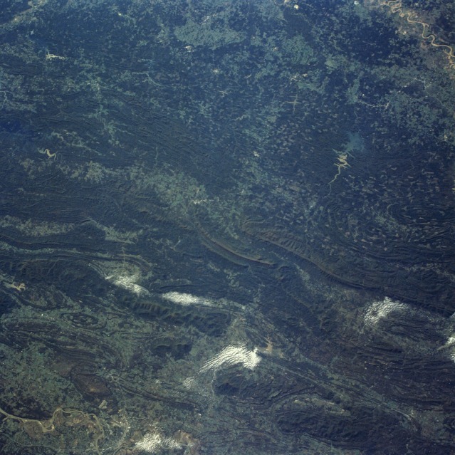 |
| STS058-091-059 Ouachita Mountains, Oklahoma and Arkansas, U.S.A. October 1993 The prominent features in this near-vertical photograph are the folded Ouachita Mountains of east-central Oklahoma and west-central Arkansas. The east-west trending, folded mountains, with their dramatic syncline and anticline structures, were formed millions of years ago and are similar to the folded Appalachian Mountains of the eastern United States. Elevation of the Ouachita Mountains ranges from 1000 feet (300 meters) to more than 2500 feet (750 meters). Visible are the east-west flowing Arkansas River to the north and a smaller section of the east-west flowing Red River to the south. Several highly reflective sediment plumes, which are probably the result of recent rains in the area, can be seen entering many of the lakes and reservoirs. The checkerboard pattern in the forested areas of the southern part of the photograph results from clear-cutting and other commercial logging operations. |
| Images: | All Available Images Low-Resolution 143k |
|
| Mission: | STS058 |
|
| Roll - Frame: | 91 - 59 |
|
| Geographical Name: | USA-ARKANSAS |
|
| Features: | OUACHITA MOUNTAINS |
|
| Center Lat x Lon: | 34.5N x 94.5W |
|
| Film Exposure: | F | N=Normal exposure, U=Under exposed, O=Over exposed, F=out of Focus |
| Percentage of Cloud Cover-CLDP: | 5 |
|
| Camera:: | HB |
|
| Camera Tilt: | 25 | LO=Low Oblique, HO=High Oblique, NV=Near Vertical |
| Camera Focal Length: | 100 |
|
| Nadir to Photo Center Direction: | SE | The direction from the nadir to the center point, N=North, S=South, E=East, W=West |
| Stereo?: | N | Y=Yes there is an adjacent picture of the same area, N=No there isn't |
| Orbit Number: | 65 |
|
| Date: | 19931022 | YYYYMMDD |
| Time: | 150734 | GMT HHMMSS |
| Nadir Lat: | 35.2N |
Latitude of suborbital point of spacecraft |
| Nadir Lon: | 95.5W |
Longitude of suborbital point of spacecraft |
| Sun Azimuth: | 129 | Clockwise angle in degrees from north to the sun measured at the nadir point |
| Space Craft Altitude: | 154 | nautical miles |
| Sun Elevation: | 27 | Angle in degrees between the horizon and the sun, measured at the nadir point |
| Land Views: | MOUNTAIN, VALLEY, FOREST |
|
| Water Views: | RIVER, RESERVOIR |
|
| Atmosphere Views: | |
|
| Man Made Views: | |
|
| City Views: | |
|
Photo is not associated with any sequences | ||
| NASA Home Page |
JSC Home Page |
JSC Digital Image Collection |
Earth Science & Remote Sensing |
|
This service is provided by the International Space Station program and the JSC Earth Science & Remote Sensing Unit, ARES Division, Exploration Integration Science Directorate.

|