Geographic Region: CHINA
Feature: BOHAI BAY,YELLOW R DELTA
|
Geographic Region: CHINA Feature: BOHAI BAY,YELLOW R DELTA |
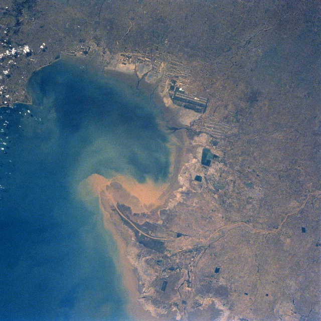 |
| STS058-090-077 Yellow River Delta, China October 1993 The Yellow River, the second longest river in China, rises in the Kunlun Mountains of western China and flows generally eastward for 3000 miles (4830 km) before emptying into the Gulf of Bohai (left center, bottom center of the image). The Gulf of Bohai is an arm of the Yellow Sea. In this south-looking view the sediment plume from the Yellow River, considered to be one of the most silt-laden rivers in the world, can be seen entering the gulf. Each year, the Yellow River discharges over one billon tons of sediment into the gulf. The delta is being extended steadily at a rate of one mile (1.6 km) a year adding roughly 14 sq. miles (40 sq. km) of land in the process. Large-scale construction of dams and reservoir systems for flood control and power production was begun along the middle and lower courses of the river in 1955. Midway between the center and right center of the image is China's second largest oilfield, the Shengli Oilfield. |
| Images: | All Available Images Low-Resolution 379k |
|
| Mission: | STS058 |
|
| Roll - Frame: | 90 - 77 |
|
| Geographical Name: | CHINA |
|
| Features: | BOHAI BAY,YELLOW R DELTA |
|
| Center Lat x Lon: | 38.5N x 118.0E |
|
| Film Exposure: | N | N=Normal exposure, U=Under exposed, O=Over exposed, F=out of Focus |
| Percentage of Cloud Cover-CLDP: | 0 |
|
| Camera:: | HB |
|
| Camera Tilt: | 33 | LO=Low Oblique, HO=High Oblique, NV=Near Vertical |
| Camera Focal Length: | 50 |
|
| Nadir to Photo Center Direction: | N | The direction from the nadir to the center point, N=North, S=South, E=East, W=West |
| Stereo?: | Y | Y=Yes there is an adjacent picture of the same area, N=No there isn't |
| Orbit Number: | 56 |
|
| Date: | 19931022 | YYYYMMDD |
| Time: | 013845 | GMT HHMMSS |
| Nadir Lat: | 37.0N |
Latitude of suborbital point of spacecraft |
| Nadir Lon: | 118.7E |
Longitude of suborbital point of spacecraft |
| Sun Azimuth: | 141 | Clockwise angle in degrees from north to the sun measured at the nadir point |
| Space Craft Altitude: | 155 | nautical miles |
| Sun Elevation: | 33 | Angle in degrees between the horizon and the sun, measured at the nadir point |
| Land Views: | PLAIN |
|
| Water Views: | RIVER, DELTA, SEDIMENT, BAY |
|
| Atmosphere Views: | |
|
| Man Made Views: | AGRICULTURE |
|
| City Views: | |
|
Photo is not associated with any sequences | ||
| NASA Home Page |
JSC Home Page |
JSC Digital Image Collection |
Earth Science & Remote Sensing |
|
This service is provided by the International Space Station program and the JSC Earth Science & Remote Sensing Unit, ARES Division, Exploration Integration Science Directorate.

|