
Geographic Region: USA-COLORADO
Feature: SAN LUIS VALLEY
|
Geographic Region: USA-COLORADO Feature: SAN LUIS VALLEY |
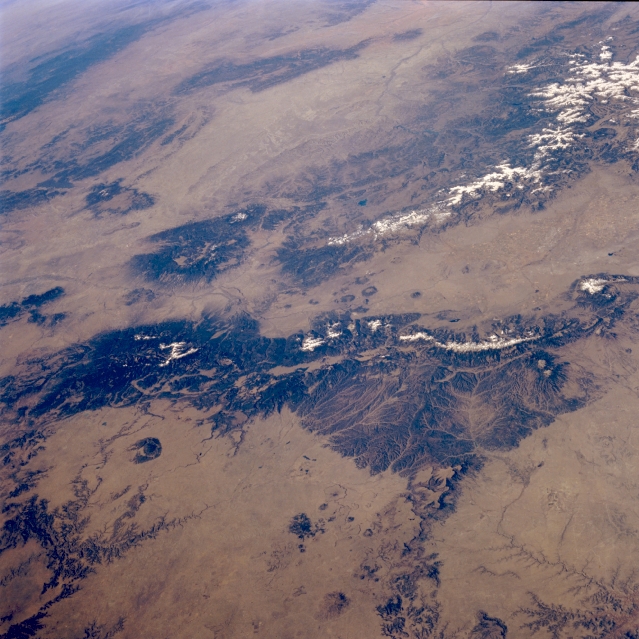 |
| STS058-090-015 Rocky Mountains, North-Central New Mexico, U.S.A. October 1993 The forested mountains and dry intermontane valleys of this portion of the Rocky Mountains in north-central New Mexico are shown in this low-oblique, west-looking photograph. Apparent are the headwaters of the Purgatoire River and many tributary streams that originate in the massive, north-south-trending, forested Sangre de Cristo Mountains (lower right corner) and the Canadian River (lower left corner). The southern extension of the San Luis Valley, part of the Rio Grande Rift that extends north-south through New Mexico, separates the slopes of the Sangre de Cristo Mountains to the east from the San Juan Mountains to the west. West of the San Juan Mountains appears the large, dry San Juan River Basin, with the Chuska Mountains to its west. Most of the circular, dark features are volcanic remnants. |
| Images: | All Available Images Low-Resolution 353k |
|
| Mission: | STS058 |
|
| Roll - Frame: | 90 - 15 |
|
| Geographical Name: | USA-COLORADO |
|
| Features: | SAN LUIS VALLEY |
|
| Center Lat x Lon: | 37.5N x 105.5W |
|
| Film Exposure: | N | N=Normal exposure, U=Under exposed, O=Over exposed, F=out of Focus |
| Percentage of Cloud Cover-CLDP: | 0 |
|
| Camera:: | HB |
|
| Camera Tilt: | LO | LO=Low Oblique, HO=High Oblique, NV=Near Vertical |
| Camera Focal Length: | 100 |
|
| Nadir to Photo Center Direction: | W | The direction from the nadir to the center point, N=North, S=South, E=East, W=West |
| Stereo?: | N | Y=Yes there is an adjacent picture of the same area, N=No there isn't |
| Orbit Number: | 50 |
|
| Date: | 19931021 | YYYYMMDD |
| Time: | 163850 | GMT HHMMSS |
| Nadir Lat: | 37.4N |
Latitude of suborbital point of spacecraft |
| Nadir Lon: | 101.1W |
Longitude of suborbital point of spacecraft |
| Sun Azimuth: | 146 | Clockwise angle in degrees from north to the sun measured at the nadir point |
| Space Craft Altitude: | 155 | nautical miles |
| Sun Elevation: | 35 | Angle in degrees between the horizon and the sun, measured at the nadir point |
| Land Views: | MOUNTAIN, VALLEY |
|
| Water Views: | |
|
| Atmosphere Views: | |
|
| Man Made Views: | |
|
| City Views: | |
|
Photo is not associated with any sequences | ||
| NASA Home Page |
JSC Home Page |
JSC Digital Image Collection |
Earth Science & Remote Sensing |
|
This service is provided by the International Space Station program and the JSC Earth Science & Remote Sensing Unit, ARES Division, Exploration Integration Science Directorate.

|