Geographic Region: SPAIN
Feature: LORCA AREA
|
Geographic Region: SPAIN Feature: LORCA AREA |
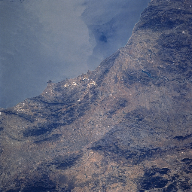 |
| STS058-089-094 Sierra de Almenara, Spain October 1993 The coast southwest of Cartagena consists of rugged mountainous terrain (darker landscape) and agricultural valleys and plains (lighter-colored features). The Sierra de Almenara is identifiable as the mountain range with a gradual curve in the alignment that is adjacent to the Mediterranean Sea. The angular-looking field patterns (light and dark areas) on the coastal side of the mountains show an altered man made landscape, created by surface mining operations. Immediately inland from these mountains, a northeast-southwest trending corridor (valley) extends diagonally across the image. The winding channel (light-colored, linear feature) of the Almanzora River, interrupted by an elongated reservoir (dark surface), can be traced across this semiarid region of southeast Spain, as the river eventually empties into the Mediterranean Sea. Surface dynamics (color contrasts) are seen in the near coastal waters of the Mediterranean Sea (upper middle). |
| Images: | All Available Images Low-Resolution 362k |
|
| Mission: | STS058 |
|
| Roll - Frame: | 89 - 94 |
|
| Geographical Name: | SPAIN |
|
| Features: | LORCA AREA |
|
| Center Lat x Lon: | 37.5N x 2W |
|
| Film Exposure: | N | N=Normal exposure, U=Under exposed, O=Over exposed, F=out of Focus |
| Percentage of Cloud Cover-CLDP: | 0 |
|
| Camera:: | HB |
|
| Camera Tilt: | 32 | LO=Low Oblique, HO=High Oblique, NV=Near Vertical |
| Camera Focal Length: | 250 |
|
| Nadir to Photo Center Direction: | S | The direction from the nadir to the center point, N=North, S=South, E=East, W=West |
| Stereo?: | Y | Y=Yes there is an adjacent picture of the same area, N=No there isn't |
| Orbit Number: | 62 |
|
| Date: | 19931022 | YYYYMMDD |
| Time: | 104237 | GMT HHMMSS |
| Nadir Lat: | 39.1N |
Latitude of suborbital point of spacecraft |
| Nadir Lon: | 1.9W |
Longitude of suborbital point of spacecraft |
| Sun Azimuth: | 158 | Clockwise angle in degrees from north to the sun measured at the nadir point |
| Space Craft Altitude: | 155 | nautical miles |
| Sun Elevation: | 37 | Angle in degrees between the horizon and the sun, measured at the nadir point |
| Land Views: | MOUNTAIN |
|
| Water Views: | WAVE |
|
| Atmosphere Views: | |
|
| Man Made Views: | |
|
| City Views: | |
|
Photo is not associated with any sequences | ||
| NASA Home Page |
JSC Home Page |
JSC Digital Image Collection |
Earth Science & Remote Sensing |
|
This service is provided by the International Space Station program and the JSC Earth Science & Remote Sensing Unit, ARES Division, Exploration Integration Science Directorate.

|