
Geographic Region: USA-COLORADO
Feature: COLORADO SPGS., PIKES PK
|
Geographic Region: USA-COLORADO Feature: COLORADO SPGS., PIKES PK |
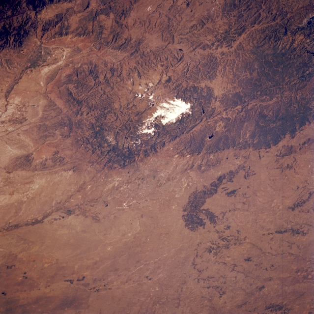 |
| STS058-089-033 Pikes Peak, Colorado, U.S.A. October 1993 Snow-capped Pikes Peak, an ancient pink granite rock, rises 14 110 feet (4300 meters) above sea level. Other mountains that make up the Pike Peak massif are Cheyenne Mountain immediately south of Pikes Peak and Rampart Range, another granite formation separated from Pikes Peak by Ute Pass, a valley between these two granite mountains. Colorado Springs, at the northeast base of Pikes Peak, is not discernible; however, a single linear feature (airport runway) is visible (bottom center). A dark arc of forest is apparent (lower right corner). Visible in South Park, one of Colorado's four big intermontane (elevated) valleys, are Elevenmile Canyon Reservoir and, to the northwest, Spinney Mountain Reservoir. The Arkansas River Valley is visible to the south. |
| Images: | All Available Images Low-Resolution 353k |
|
| Mission: | STS058 |
|
| Roll - Frame: | 89 - 33 |
|
| Geographical Name: | USA-COLORADO |
|
| Features: | COLORADO SPGS., PIKES PK |
|
| Center Lat x Lon: | 39.0N x 105W |
|
| Film Exposure: | N | N=Normal exposure, U=Under exposed, O=Over exposed, F=out of Focus |
| Percentage of Cloud Cover-CLDP: | 0 |
|
| Camera:: | HB |
|
| Camera Tilt: | 47 | LO=Low Oblique, HO=High Oblique, NV=Near Vertical |
| Camera Focal Length: | 250 |
|
| Nadir to Photo Center Direction: | NE | The direction from the nadir to the center point, N=North, S=South, E=East, W=West |
| Stereo?: | Y | Y=Yes there is an adjacent picture of the same area, N=No there isn't |
| Orbit Number: | 52 |
|
| Date: | 19931021 | YYYYMMDD |
| Time: | 194715 | GMT HHMMSS |
| Nadir Lat: | 36.9N |
Latitude of suborbital point of spacecraft |
| Nadir Lon: | 106.9W |
Longitude of suborbital point of spacecraft |
| Sun Azimuth: | 198 | Clockwise angle in degrees from north to the sun measured at the nadir point |
| Space Craft Altitude: | 156 | nautical miles |
| Sun Elevation: | 41 | Angle in degrees between the horizon and the sun, measured at the nadir point |
| Land Views: | MOUNTAIN, VALLEY |
|
| Water Views: | |
|
| Atmosphere Views: | |
|
| Man Made Views: | |
|
| City Views: | |
|
Photo is not associated with any sequences | ||
| NASA Home Page |
JSC Home Page |
JSC Digital Image Collection |
Earth Science & Remote Sensing |
|
This service is provided by the International Space Station program and the JSC Earth Science & Remote Sensing Unit, ARES Division, Exploration Integration Science Directorate.

|