
Geographic Region: USA-COLORADO
Feature: LEADVILLE AREA
|
Geographic Region: USA-COLORADO Feature: LEADVILLE AREA |
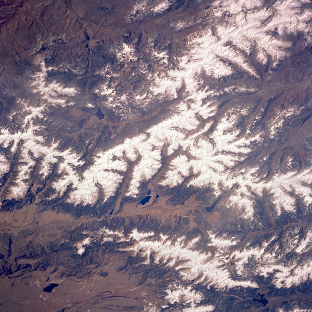 |
| STS058-089-032 Sawatch Mountains, Colorado, U.S.A. October 1993 Snow-covered mountains and several large reservoirs are clearly visible in this low-oblique photograph of central Colorado. Dark Antero Reservoir (bottom of photograph) is part of the western edge of South Park, one of Colorado's large intermontane (elevated) valleys. Twin Lakes Reservoir (center of photograph) is part of the headwaters for the Arkansas River; however, to the north, the smaller, elongated reservoir is more accurately the headwater source for the Arkansas. The Arkansas River Valley separates the Mosquto Range to the east from the higher and more massive Sawatch Mountains to the west. Taylor River Valley and Taylor Park Reservoir, which form a tributary of the Gunnison River, are visible west of the Sawatch Mountains. To the north lies dark Dillon Reservoir. |
| Images: | All Available Images Low-Resolution 394k |
|
| Mission: | STS058 |
|
| Roll - Frame: | 89 - 32 |
|
| Geographical Name: | USA-COLORADO |
|
| Features: | LEADVILLE AREA |
|
| Center Lat x Lon: | 39.0N x 106.5W |
|
| Film Exposure: | N | N=Normal exposure, U=Under exposed, O=Over exposed, F=out of Focus |
| Percentage of Cloud Cover-CLDP: | 0 |
|
| Camera:: | HB |
|
| Camera Tilt: | 44 | LO=Low Oblique, HO=High Oblique, NV=Near Vertical |
| Camera Focal Length: | 250 |
|
| Nadir to Photo Center Direction: | NE | The direction from the nadir to the center point, N=North, S=South, E=East, W=West |
| Stereo?: | N | Y=Yes there is an adjacent picture of the same area, N=No there isn't |
| Orbit Number: | 52 |
|
| Date: | 19931021 | YYYYMMDD |
| Time: | 194657 | GMT HHMMSS |
| Nadir Lat: | 37.2N |
Latitude of suborbital point of spacecraft |
| Nadir Lon: | 108.2W |
Longitude of suborbital point of spacecraft |
| Sun Azimuth: | 196 | Clockwise angle in degrees from north to the sun measured at the nadir point |
| Space Craft Altitude: | 156 | nautical miles |
| Sun Elevation: | 41 | Angle in degrees between the horizon and the sun, measured at the nadir point |
| Land Views: | MOUNTAIN, VALLEY |
|
| Water Views: | RIVER, RESERVOIR |
|
| Atmosphere Views: | |
|
| Man Made Views: | |
|
| City Views: | |
|
Photo is not associated with any sequences | ||
| NASA Home Page |
JSC Home Page |
JSC Digital Image Collection |
Earth Science & Remote Sensing |
|
This service is provided by the International Space Station program and the JSC Earth Science & Remote Sensing Unit, ARES Division, Exploration Integration Science Directorate.

|