
Geographic Region: USA-PENNSYLVANIA
Feature: SUSQUEHANNA RIVER
|
Geographic Region: USA-PENNSYLVANIA Feature: SUSQUEHANNA RIVER |
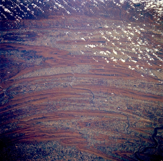 |
| STS058-088-089 Folded Appalachian Mountains, Pennsylvania October 1993 Several individual mountain ranges of the folded Appalachian Mountains in south central Pennsylvania can be distinguished in this northwest view. Starting at the bottom of the image, where part of the intensively cultivated Cumberland Valley west of Harrisburg is visible, the individual ranges include the Blue Mountains, the Tuscarora Mountains, Jacks Mountain, Tussey Mountain, and Bald Eagle Mountain. The Juniata River, a branch of the larger Susquehanna River (lower right corner), is the thin, dark feature that has created water gaps though some of the ridges in this ridge and valley landscape. The location of Lewisville, Pennsylvania is barely discernible near the center of the image where the Juniata River makes a U-shaped turn. Some colorful autumn foliage is visible on the forested mountain ridges. Maximum elevations above sea level for many of these ridges range from 1500 to 2500 feet (455 to 760 meters). |
| Images: | All Available Images Low-Resolution 408k |
|
| Mission: | STS058 |
|
| Roll - Frame: | 88 - 89 |
|
| Geographical Name: | USA-PENNSYLVANIA |
|
| Features: | SUSQUEHANNA RIVER |
|
| Center Lat x Lon: | 40.0N x 77W |
|
| Film Exposure: | N | N=Normal exposure, U=Under exposed, O=Over exposed, F=out of Focus |
| Percentage of Cloud Cover-CLDP: | 5 |
|
| Camera:: | HB |
|
| Camera Tilt: | 34 | LO=Low Oblique, HO=High Oblique, NV=Near Vertical |
| Camera Focal Length: | 250 |
|
| Nadir to Photo Center Direction: | N | The direction from the nadir to the center point, N=North, S=South, E=East, W=West |
| Stereo?: | Y | Y=Yes there is an adjacent picture of the same area, N=No there isn't |
| Orbit Number: | 66 |
|
| Date: | 19931022 | YYYYMMDD |
| Time: | 164623 | GMT HHMMSS |
| Nadir Lat: | 38.3N |
Latitude of suborbital point of spacecraft |
| Nadir Lon: | 76.8W |
Longitude of suborbital point of spacecraft |
| Sun Azimuth: | 178 | Clockwise angle in degrees from north to the sun measured at the nadir point |
| Space Craft Altitude: | 155 | nautical miles |
| Sun Elevation: | 41 | Angle in degrees between the horizon and the sun, measured at the nadir point |
| Land Views: | MOUNTAIN |
|
| Water Views: | RIVER |
|
| Atmosphere Views: | |
|
| Man Made Views: | |
|
| City Views: | |
|
Photo is not associated with any sequences | ||
| NASA Home Page |
JSC Home Page |
JSC Digital Image Collection |
Earth Science & Remote Sensing |
|
This service is provided by the International Space Station program and the JSC Earth Science & Remote Sensing Unit, ARES Division, Exploration Integration Science Directorate.

|