
Geographic Region: USA-MARYLAND
Feature: CUMBERLAND AREA
|
Geographic Region: USA-MARYLAND Feature: CUMBERLAND AREA |
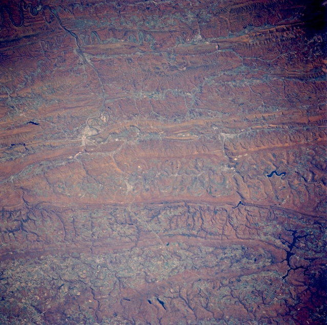 |
| STS058-088-085 Cumberland Area, Maryland, U.S.A. October 1993 Many paralleling low mountain ridges and their intervening valleys of the northeast-southwest trending Appalachian Mountains are visible in this southeast looking view of parts of Maryland, West Virginia, and Pennsylvania. Many of the valleys have well entrenched drainage patterns that show up on this autumn scene. The lighter color feature near the left middle side of the image shows the location of Cumberland (Maryland), and the east-west aligned light-colored line that passes Cumberland is the Interstate Highway 68 right of way and parts of U.S. Highway 40 as these roadways cut through the mountainous terrain. Three reservoirs (dark features) can be identified in the lower right quadrant of the picture: Deep Creek Lake (largest of the three lakes); Jennings Randolph Lake (medium sized of the three located on the North Branch of the Potomac River); and the Savage River Reservoir (smallest of the three lakes). The reservoir northwest of the Cumberland area is the Gordon River (Pennsylvania). STS058-088-086 is a companion image to this view but shows more terrain in Pennsylvania, and the Potomac River is easier to identify (upper center). |
| Images: | All Available Images Low-Resolution 383k |
|
| Mission: | STS058 |
|
| Roll - Frame: | 88 - 85 |
|
| Geographical Name: | USA-MARYLAND |
|
| Features: | CUMBERLAND AREA |
|
| Center Lat x Lon: | 39.5N x 79W |
|
| Film Exposure: | N | N=Normal exposure, U=Under exposed, O=Over exposed, F=out of Focus |
| Percentage of Cloud Cover-CLDP: | 0 |
|
| Camera:: | HB |
|
| Camera Tilt: | 25 | LO=Low Oblique, HO=High Oblique, NV=Near Vertical |
| Camera Focal Length: | 250 |
|
| Nadir to Photo Center Direction: | NW | The direction from the nadir to the center point, N=North, S=South, E=East, W=West |
| Stereo?: | Y | Y=Yes there is an adjacent picture of the same area, N=No there isn't |
| Orbit Number: | 66 |
|
| Date: | 19931022 | YYYYMMDD |
| Time: | 164605 | GMT HHMMSS |
| Nadir Lat: | 38.5N |
Latitude of suborbital point of spacecraft |
| Nadir Lon: | 78.3W |
Longitude of suborbital point of spacecraft |
| Sun Azimuth: | 176 | Clockwise angle in degrees from north to the sun measured at the nadir point |
| Space Craft Altitude: | 155 | nautical miles |
| Sun Elevation: | 40 | Angle in degrees between the horizon and the sun, measured at the nadir point |
| Land Views: | MOUNTAIN, VALLEY, FOREST |
|
| Water Views: | RIVER, RESERVOIR |
|
| Atmosphere Views: | |
|
| Man Made Views: | HIGHWAY |
|
| City Views: | |
|
Photo is not associated with any sequences | ||
| NASA Home Page |
JSC Home Page |
JSC Digital Image Collection |
Earth Science & Remote Sensing |
|
This service is provided by the International Space Station program and the JSC Earth Science & Remote Sensing Unit, ARES Division, Exploration Integration Science Directorate.

|