
Geographic Region: USA-MARYLAND
Feature: DEEP CREEK LAKE AREA
|
Geographic Region: USA-MARYLAND Feature: DEEP CREEK LAKE AREA |
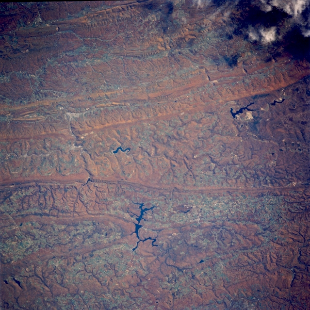 |
| STS058-088-084 Appalachian Mountains; Deep Creek Lake, Maryland, U.S.A. October 1993 The linear ridges and valleys of the Appalachian Mountains can be seen in this beautiful near-nadir looking view. Acquired during the fall of the year, the image depicts the reddish colors of the autumn foliage. The southern and middle Appalachians are capped with the most richly varied deciduous forest in North America. The fertile grooves, broad valleys, and myriad streams offer congenial habitats to a remarkable diversity of plant and animal life. Once a great mountain range attaining altitudes of over 17000 feet (5185 meters), hundreds of millions of years of erosion have reduced the Appalachians to their present 2000 to 4000 feet (610 to 1220 meters) altitude. Rivers have expanded valleys and have even cut through many of the mountain ranges on their journey eastward toward the Atlantic Ocean. This particular view is centered in western Maryland in the vicinity of Deep Creek Lake (located midway between the center and bottom center of the image). The large lake in the upper right portion of the image is Mount Storm Lake. |
| Images: | All Available Images Low-Resolution 382k |
|
| Mission: | STS058 |
|
| Roll - Frame: | 88 - 84 |
|
| Geographical Name: | USA-MARYLAND |
|
| Features: | DEEP CREEK LAKE AREA |
|
| Center Lat x Lon: | 39.5N x 79.5W |
|
| Film Exposure: | N | N=Normal exposure, U=Under exposed, O=Over exposed, F=out of Focus |
| Percentage of Cloud Cover-CLDP: | 0 |
|
| Camera:: | HB |
|
| Camera Tilt: | 30 | LO=Low Oblique, HO=High Oblique, NV=Near Vertical |
| Camera Focal Length: | 250 |
|
| Nadir to Photo Center Direction: | NW | The direction from the nadir to the center point, N=North, S=South, E=East, W=West |
| Stereo?: | Y | Y=Yes there is an adjacent picture of the same area, N=No there isn't |
| Orbit Number: | 66 |
|
| Date: | 19931022 | YYYYMMDD |
| Time: | 164603 | GMT HHMMSS |
| Nadir Lat: | 38.5N |
Latitude of suborbital point of spacecraft |
| Nadir Lon: | 78.4W |
Longitude of suborbital point of spacecraft |
| Sun Azimuth: | 176 | Clockwise angle in degrees from north to the sun measured at the nadir point |
| Space Craft Altitude: | 155 | nautical miles |
| Sun Elevation: | 40 | Angle in degrees between the horizon and the sun, measured at the nadir point |
| Land Views: | MOUNTAIN, FOREST |
|
| Water Views: | LAKE |
|
| Atmosphere Views: | |
|
| Man Made Views: | |
|
| City Views: | |
|
Photo is not associated with any sequences | ||
| NASA Home Page |
JSC Home Page |
JSC Digital Image Collection |
Earth Science & Remote Sensing |
|
This service is provided by the International Space Station program and the JSC Earth Science & Remote Sensing Unit, ARES Division, Exploration Integration Science Directorate.

|