
Geographic Region: USA-WEST VIRGINIA
Feature: OTTER CREEK WILDERNESS
|
Geographic Region: USA-WEST VIRGINIA Feature: OTTER CREEK WILDERNESS |
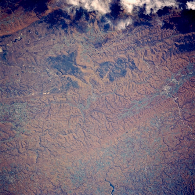 |
| STS058-088-082 Appalachian Mountains, Elkins, West Virginia October 1993 The fall foliage of the tree-covered Appalachian Mountains is visible in this southeast-looking view. The Appalachian Mountains are an eroded remnant of a great mountain mass that was formed by the collision of the North American and African continents millions of years ago. The mountains are heavily wooded and are covered with the most richly varied deciduous forest in North America. Fire scars from a previous forest fire appear as a dark blue or black area slightly above the center of the image. The city of Elkins, located near the left-center of the image, is situated on the Tygart River. Elkins is the center of a timber and mining region. The eastern portion of Tygart Lake can be seen near the bottom-center of the image. |
| Images: | All Available Images Low-Resolution 387k |
|
| Mission: | STS058 |
|
| Roll - Frame: | 88 - 82 |
|
| Geographical Name: | USA-WEST VIRGINIA |
|
| Features: | OTTER CREEK WILDERNESS |
|
| Center Lat x Lon: | 39.0N x 79.5W |
|
| Film Exposure: | N | N=Normal exposure, U=Under exposed, O=Over exposed, F=out of Focus |
| Percentage of Cloud Cover-CLDP: | 5 |
|
| Camera:: | HB |
|
| Camera Tilt: | 18 | LO=Low Oblique, HO=High Oblique, NV=Near Vertical |
| Camera Focal Length: | 250 |
|
| Nadir to Photo Center Direction: | NW | The direction from the nadir to the center point, N=North, S=South, E=East, W=West |
| Stereo?: | Y | Y=Yes there is an adjacent picture of the same area, N=No there isn't |
| Orbit Number: | 66 |
|
| Date: | 19931022 | YYYYMMDD |
| Time: | 164558 | GMT HHMMSS |
| Nadir Lat: | 38.5N |
Latitude of suborbital point of spacecraft |
| Nadir Lon: | 78.8W |
Longitude of suborbital point of spacecraft |
| Sun Azimuth: | 175 | Clockwise angle in degrees from north to the sun measured at the nadir point |
| Space Craft Altitude: | 155 | nautical miles |
| Sun Elevation: | 40 | Angle in degrees between the horizon and the sun, measured at the nadir point |
| Land Views: | MOUNTAIN, FOREST, PLATEAU |
|
| Water Views: | |
|
| Atmosphere Views: | |
|
| Man Made Views: | |
|
| City Views: | |
|
Photo is not associated with any sequences | ||
| NASA Home Page |
JSC Home Page |
JSC Digital Image Collection |
Earth Science & Remote Sensing |
|
This service is provided by the International Space Station program and the JSC Earth Science & Remote Sensing Unit, ARES Division, Exploration Integration Science Directorate.

|