
Geographic Region: USA-MISSOURI
Feature: MISSOURI RIVER, COLOMBIA
|
Geographic Region: USA-MISSOURI Feature: MISSOURI RIVER, COLOMBIA |
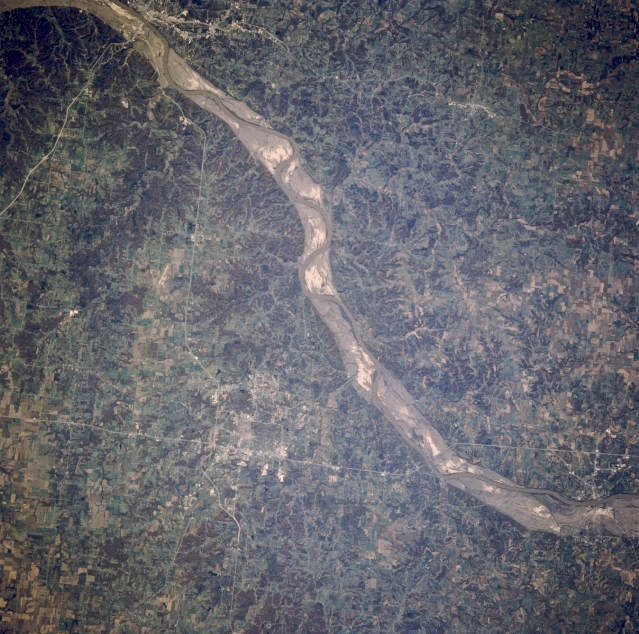 |
| STS058-088-054 Missouri River and Columbia, Missouri, U.S.A. October 1993 Visible in this near-vertical photograph is a portion of the generally southeast-trending Missouri River and its scoured sand and gravel floodplain between Boonville (lower right) and Jefferson City (upper left). The once rich agricultural fields of the floodplain have disappeared because of the floods of the spring and early summer of 1993. Bluffs on either side of the floodplain can exceed 250 feet (76 meters). East of the river is Columbia (below center), a trade center in a farm and coal mining region. Columbia is the home of the University of Missouri and has a well known medical center. Interstate Highway 70 skirts the northern portions of the city. |
| Images: | All Available Images Low-Resolution 389k |
|
| Mission: | STS058 |
|
| Roll - Frame: | 88 - 54 |
|
| Geographical Name: | USA-MISSOURI |
|
| Features: | MISSOURI RIVER, COLOMBIA |
|
| Center Lat x Lon: | 39.0N x 92.5W |
|
| Film Exposure: | N | N=Normal exposure, U=Under exposed, O=Over exposed, F=out of Focus |
| Percentage of Cloud Cover-CLDP: | 0 |
|
| Camera:: | HB |
|
| Camera Tilt: | 13 | LO=Low Oblique, HO=High Oblique, NV=Near Vertical |
| Camera Focal Length: | 250 |
|
| Nadir to Photo Center Direction: | W | The direction from the nadir to the center point, N=North, S=South, E=East, W=West |
| Stereo?: | N | Y=Yes there is an adjacent picture of the same area, N=No there isn't |
| Orbit Number: | 66 |
|
| Date: | 19931022 | YYYYMMDD |
| Time: | 164317 | GMT HHMMSS |
| Nadir Lat: | 39.1N |
Latitude of suborbital point of spacecraft |
| Nadir Lon: | 91.9W |
Longitude of suborbital point of spacecraft |
| Sun Azimuth: | 159 | Clockwise angle in degrees from north to the sun measured at the nadir point |
| Space Craft Altitude: | 155 | nautical miles |
| Sun Elevation: | 37 | Angle in degrees between the horizon and the sun, measured at the nadir point |
| Land Views: | VALLEY |
|
| Water Views: | RIVER |
|
| Atmosphere Views: | |
|
| Man Made Views: | URBAN AREA |
|
| City Views: | COLUMBIA |
|
Photo is not associated with any sequences | ||
| NASA Home Page |
JSC Home Page |
JSC Digital Image Collection |
Earth Science & Remote Sensing |
|
This service is provided by the International Space Station program and the JSC Earth Science & Remote Sensing Unit, ARES Division, Exploration Integration Science Directorate.

|