
Geographic Region: USA-KANSAS
Feature: MISSOURI RIVER, MARSHAL
|
Geographic Region: USA-KANSAS Feature: MISSOURI RIVER, MARSHAL |
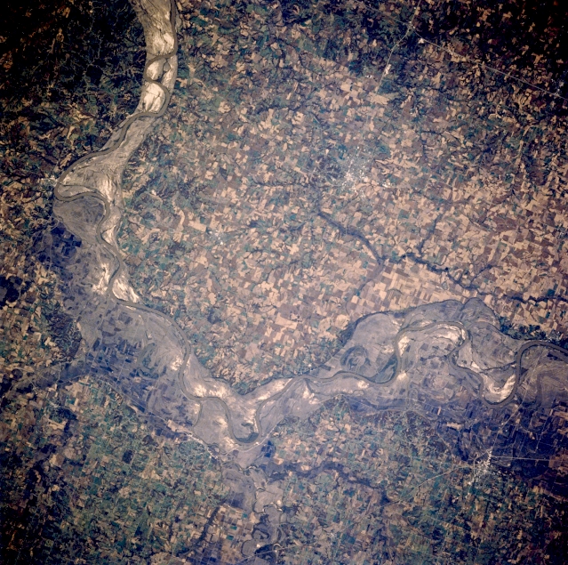 |
| STS058-088-053 Missouri River and Marshall, Missouri, U.S.A. October 1993 Apparent in this near-vertical photograph are the east-flowing Missouri River and scars of the spring and early summer floods of 1993. The bluffs on either side of the Missouri River rise to 200 feet (63 meters) above the scoured, sandy landscape in the floodplain that formerly contained numerous agriculture field patterns. Many highways and roads in the floodplain were under water during the height of the flooding, which was considered the worst in more than 100 years. Marshall (above right of center), a commercial and transportation hub in the middle of a prime agricultural region, is discernible south of the Missouri River. |
| Images: | All Available Images Low-Resolution 435k |
|
| Mission: | STS058 |
|
| Roll - Frame: | 88 - 53 |
|
| Geographical Name: | USA-KANSAS |
|
| Features: | MISSOURI RIVER, MARSHAL |
|
| Center Lat x Lon: | 39.0N x 93W |
|
| Film Exposure: | N | N=Normal exposure, U=Under exposed, O=Over exposed, F=out of Focus |
| Percentage of Cloud Cover-CLDP: | 0 |
|
| Camera:: | HB |
|
| Camera Tilt: | 7 | LO=Low Oblique, HO=High Oblique, NV=Near Vertical |
| Camera Focal Length: | 250 |
|
| Nadir to Photo Center Direction: | W | The direction from the nadir to the center point, N=North, S=South, E=East, W=West |
| Stereo?: | Y | Y=Yes there is an adjacent picture of the same area, N=No there isn't |
| Orbit Number: | 66 |
|
| Date: | 19931022 | YYYYMMDD |
| Time: | 164307 | GMT HHMMSS |
| Nadir Lat: | 39.1N |
Latitude of suborbital point of spacecraft |
| Nadir Lon: | 92.7W |
Longitude of suborbital point of spacecraft |
| Sun Azimuth: | 158 | Clockwise angle in degrees from north to the sun measured at the nadir point |
| Space Craft Altitude: | 155 | nautical miles |
| Sun Elevation: | 37 | Angle in degrees between the horizon and the sun, measured at the nadir point |
| Land Views: | VALLEY |
|
| Water Views: | RIVER |
|
| Atmosphere Views: | |
|
| Man Made Views: | AGRICULTURE |
|
| City Views: | |
|
Photo is not associated with any sequences | ||
| NASA Home Page |
JSC Home Page |
JSC Digital Image Collection |
Earth Science & Remote Sensing |
|
This service is provided by the International Space Station program and the JSC Earth Science & Remote Sensing Unit, ARES Division, Exploration Integration Science Directorate.

|