
Geographic Region: USA-KANSAS
Feature: WICHITA/ HUTCHISON AREA
|
Geographic Region: USA-KANSAS Feature: WICHITA/ HUTCHISON AREA |
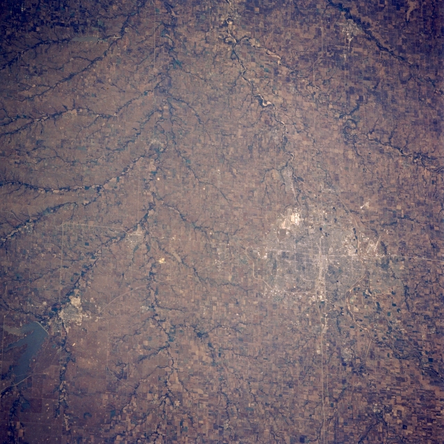 |
| STS058-088-045 Wichita and Flint Hills, Kansas, U.S.A. October 1993 Wichita and the grass-covered, rolling terrain of the Flint Hills to its east are featured in this south-looking, low-oblique photograph. Wichita, the chief commercial and industrial center of southern Kansas, was founded in 1868 by settlers serving the famed Chisholm Trail and became a boom town in the 1870s and 1880s as a trade center for livestock and agriculture. Oil was discovered in the Flint Hills in 1915. An important aircraft manufacturing center, Wichita also has railroad shops, flour mills, meat packing plants, grain elevators, oil refineries, heating and air conditioning plants, pharmaceuticals manufacturers, printing plants, and stockyards. Several manmade features are discernible--north-south-oriented Interstate Highway 35; runways of McConnell Air Force Base southeast of the city; and El Dorado and El Dorado Reservoir to the northeast. The Arkansas River is barely discernible flowing south-southeast from Wichita. |
| Images: | All Available Images Low-Resolution 384k |
|
| Mission: | STS058 |
|
| Roll - Frame: | 88 - 45 |
|
| Geographical Name: | USA-KANSAS |
|
| Features: | WICHITA/ HUTCHISON AREA |
|
| Center Lat x Lon: | 38.0N x 97.5W |
|
| Film Exposure: | N | N=Normal exposure, U=Under exposed, O=Over exposed, F=out of Focus |
| Percentage of Cloud Cover-CLDP: | 0 |
|
| Camera:: | HB |
|
| Camera Tilt: | 29 | LO=Low Oblique, HO=High Oblique, NV=Near Vertical |
| Camera Focal Length: | 250 |
|
| Nadir to Photo Center Direction: | SW | The direction from the nadir to the center point, N=North, S=South, E=East, W=West |
| Stereo?: | Y | Y=Yes there is an adjacent picture of the same area, N=No there isn't |
| Orbit Number: | 66 |
|
| Date: | 19931022 | YYYYMMDD |
| Time: | 164222 | GMT HHMMSS |
| Nadir Lat: | 38.9N |
Latitude of suborbital point of spacecraft |
| Nadir Lon: | 96.4W |
Longitude of suborbital point of spacecraft |
| Sun Azimuth: | 153 | Clockwise angle in degrees from north to the sun measured at the nadir point |
| Space Craft Altitude: | 155 | nautical miles |
| Sun Elevation: | 36 | Angle in degrees between the horizon and the sun, measured at the nadir point |
| Land Views: | PLAIN |
|
| Water Views: | |
|
| Atmosphere Views: | |
|
| Man Made Views: | URBAN AREA, AGRICULTURE |
|
| City Views: | WICHITA |
|
Photo is not associated with any sequences | ||
| NASA Home Page |
JSC Home Page |
JSC Digital Image Collection |
Earth Science & Remote Sensing |
|
This service is provided by the International Space Station program and the JSC Earth Science & Remote Sensing Unit, ARES Division, Exploration Integration Science Directorate.

|