 Photo #: STS058-88-37 Date: Oct. 1993
Geographic Region: USA-COLORADO
Feature: SAN LUIS VALLEY, DUNES

 Photo #: STS058-88-37 Date: Oct. 1993 Photo #: STS058-88-37 Date: Oct. 1993Geographic Region: USA-COLORADO Feature: SAN LUIS VALLEY, DUNES |
 |
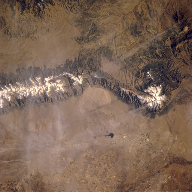
| STS058-088-037 Sangre de Cristo Mountains, Colorado, U.S.A. October 1993 Featured in this near-vertical photograph of south-central Colorado is part of the generally north-south-trending Sangre de Cristo Mountains with a snow-covered ridge line at elevations above 10 000 feet (3048 meters). Apparent are the sharply faulted slopes of the western side of the mountain range and snow-covered Blanca Peak [14 345 feet (4372 meters)]. Center-pivot irrigation (circular field patterns) has allowed the arid San Luis Valley to become an intensive agriculture region. Intermittently flowing San Luis Creek, a tributary of the Rio Grande, is barely visible as it flows south to merge with the Rio Grande near Alamosa. Dark San Luis Lake, southwest of Great Sand Dunes National Monument, lies along the drainage path of San Luis Creek. Barely discernible are two jet aircraft contrails and their shadows. |
| Images: | All Available Images Low-Resolution 330k |
|
| Mission: | STS058 |
|
| Roll - Frame: | 88 - 37 |
|
| Geographical Name: | USA-COLORADO |
|
| Features: | SAN LUIS VALLEY, DUNES |
|
| Center Lat x Lon: | 38.0N x 105.5W |
|
| Film Exposure: | N | N=Normal exposure, U=Under exposed, O=Over exposed, F=out of Focus |
| Percentage of Cloud Cover-CLDP: | 0 |
|
| Camera:: | HB |
|
| Camera Tilt: | 34 | LO=Low Oblique, HO=High Oblique, NV=Near Vertical |
| Camera Focal Length: | 250 |
|
| Nadir to Photo Center Direction: | W | The direction from the nadir to the center point, N=North, S=South, E=East, W=West |
| Stereo?: | Y | Y=Yes there is an adjacent picture of the same area, N=No there isn't |
| Orbit Number: | 66 |
|
| Date: | 19931022 | YYYYMMDD |
| Time: | 164050 | GMT HHMMSS |
| Nadir Lat: | 38.2N |
Latitude of suborbital point of spacecraft |
| Nadir Lon: | 103.8W |
Longitude of suborbital point of spacecraft |
| Sun Azimuth: | 144 | Clockwise angle in degrees from north to the sun measured at the nadir point |
| Space Craft Altitude: | 155 | nautical miles |
| Sun Elevation: | 33 | Angle in degrees between the horizon and the sun, measured at the nadir point |
| Land Views: | MOUNTAIN, DUNE |
|
| Water Views: | RIVER |
|
| Atmosphere Views: | |
|
| Man Made Views: | PIVOT IRRIGATION |
|
| City Views: | |
|
Photo is not associated with any sequences | ||
| NASA Home Page |
JSC Home Page |
JSC Digital Image Collection |
Earth Science & Remote Sensing |
|
|