
Geographic Region: USA-WYOMING
Feature: YELLOWSTONE LAKE, MTS.
|
Geographic Region: USA-WYOMING Feature: YELLOWSTONE LAKE, MTS. |
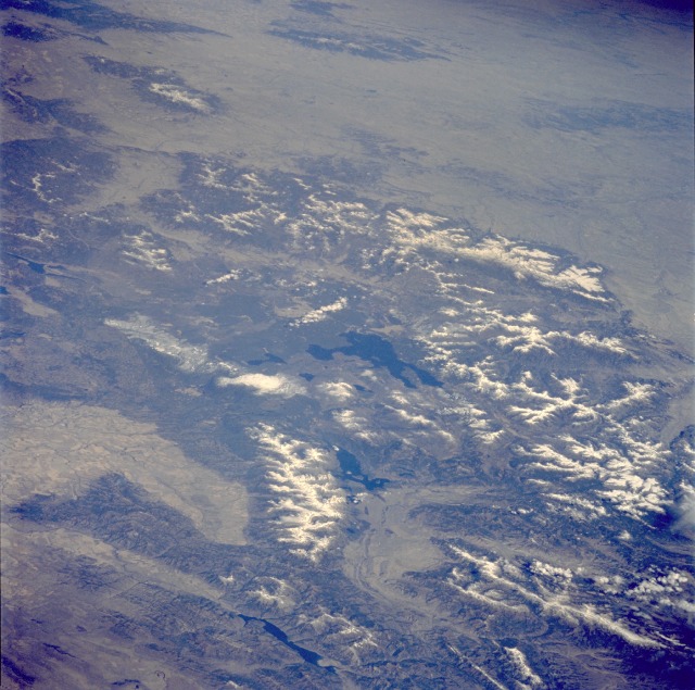 |
| STS058-085-091 Teton Range and Yellowstone National Park, Idaho, Montana, and Wyoming, U.S.A. October 1993 This low-oblique, northeast-looking photograph of the majestic Grand Teton National Park and Yellowstone National Park region, together one of the world's largest wildlife sanctuaries, is one of the best photographs of this area obtained to date. Yellowstone, the oldest national park in the world, lies mainly on a broad plateau of the Rocky Mountains on the Continental Divide at 8000 feet (2440 meters) above sea level. Most of the plateau is formed from once molten lava. Volcanic activity is still evidenced by the nearly 10 000 hot springs, 200 geysers, and many vents and hot mud pots. The more prominent geysers, such as Old Faithful (not visible in the photograph), are unequaled in size, power, and variety of action. Even after the destructive fires of 1988, forests now cover nearly 85 percent of the Yellowstone region. Yellowstone Lake, pictured at the center of the photograph, covering an area of 139 square miles (360 square kilometers), is the largest high-altitude [7331 feet (2236 meters) above sea level] lake in North America. Using Yellowstone as the pivot, several mountain ranges are discernible--north, east, and southeast are the snow-covered Absaroka Mountains, north and northeast of which are the smaller Crazy Mountains and Big Snowy Mountains of southern Montana; south are the northern portions of the Wind River Range; farther to the southwest lies the awesome, snow-covered Teton Range, rugged fault-block mountains that rise more than 13 500 feet (4118 meters) above sea level, are 40 miles (65 kilometers) long, and are 10 to 15 miles (16 to 24 kilometers) wide. Paralleling the Tetons to the east are Jackson Lake and Jackson Hole, a depression 50 miles (80 kilometers) long and 6 to 8 miles (9 to 13 kilometers) wide. The blue water of the Palisade Reservoir and the valley of the Snake River with its many agricultural fields are visible south and west of the Teton Range, respectively. Yellowstone Lake and the surrounding Plateau are centered in this scene of northwestern Wyoming, and adjacent Idaho and Montana. The view extends across the Absaroka Range to Billings, on the Yellowstone River at the upper right edge of the photograph. Jackson Lake, Jackson Hole (valley) and the Grand Tetons extend from the Yellowstone Plateau toward the camera. |
| Images: | All Available Images Low-Resolution 135k |
|
| Mission: | STS058 |
|
| Roll - Frame: | 85 - 91 |
|
| Geographical Name: | USA-WYOMING |
|
| Features: | YELLOWSTONE LAKE, MTS. |
|
| Center Lat x Lon: | 44.5N x 110.5W |
|
| Film Exposure: | N | N=Normal exposure, U=Under exposed, O=Over exposed, F=out of Focus |
| Percentage of Cloud Cover-CLDP: | 0 |
|
| Camera:: | HB |
|
| Camera Tilt: | LO | LO=Low Oblique, HO=High Oblique, NV=Near Vertical |
| Camera Focal Length: | 100 |
|
| Nadir to Photo Center Direction: | The direction from the nadir to the center point, N=North, S=South, E=East, W=West |
|
| Stereo?: | Y | Y=Yes there is an adjacent picture of the same area, N=No there isn't |
| Orbit Number: | |
|
| Date: | 1993____ | YYYYMMDD |
| Time: | GMT HHMMSS |
|
| Nadir Lat: | N |
Latitude of suborbital point of spacecraft |
| Nadir Lon: | E |
Longitude of suborbital point of spacecraft |
| Sun Azimuth: | Clockwise angle in degrees from north to the sun measured at the nadir point |
|
| Space Craft Altitude: | nautical miles |
|
| Sun Elevation: | Angle in degrees between the horizon and the sun, measured at the nadir point |
|
| Land Views: | MOUNTAIN, VOLCANO, CRATER, VALLEY, FOREST |
|
| Water Views: | LAKE, RIVER |
|
| Atmosphere Views: | |
|
| Man Made Views: | |
|
| City Views: | |
|
Photo is not associated with any sequences | ||
| NASA Home Page |
JSC Home Page |
JSC Digital Image Collection |
Earth Science & Remote Sensing |
|
This service is provided by the International Space Station program and the JSC Earth Science & Remote Sensing Unit, ARES Division, Exploration Integration Science Directorate.

|