
Geographic Region: USA-IDAHO
Feature: SNAKE RIVER, MOUNTAINS
|
Geographic Region: USA-IDAHO Feature: SNAKE RIVER, MOUNTAINS |
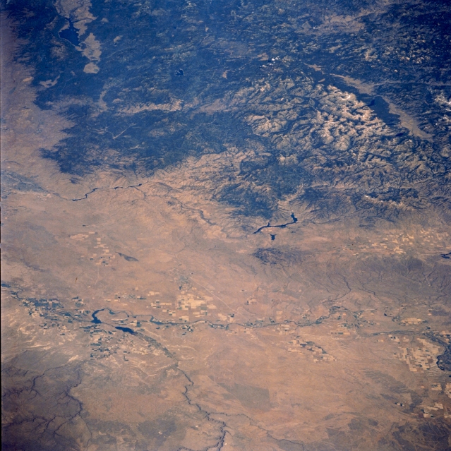 |
| STS058-085-083 Snake River Valley, Idaho, U.S.A. October 1993 The Snake River Valley and the southwestern Salmon River Mountains are featured in this north-northeast-looking, low-oblique photograph. The Snake River Valley, a vast lava plateau built up by repeated outpourings of volcanic rock nearly 20 million years ago, contains high plains, immense fields of volcanic rubble, deep gorges, and fertile volcanic soil that produces abundant potato crops. Much of the westward-flowing Snake River and its tributaries that are used for irrigation and the south-southeast path of the Bruneau River are apparent in the bottom half of the photograph. Visible near the center of the photograph are the Anderson Ranch Reservoir; to its left appear Lucky Peak Reservoir and the barely discernible city of Boise. The large Cascade Reservoir is visible near the upper left of the photograph. |
| Images: | All Available Images Low-Resolution 370k |
|
| Mission: | STS058 |
|
| Roll - Frame: | 85 - 83 |
|
| Geographical Name: | USA-IDAHO |
|
| Features: | SNAKE RIVER, MOUNTAINS |
|
| Center Lat x Lon: | 43.5N x 115.5W |
|
| Film Exposure: | N | N=Normal exposure, U=Under exposed, O=Over exposed, F=out of Focus |
| Percentage of Cloud Cover-CLDP: | 0 |
|
| Camera:: | HB |
|
| Camera Tilt: | LO | LO=Low Oblique, HO=High Oblique, NV=Near Vertical |
| Camera Focal Length: | 100 |
|
| Nadir to Photo Center Direction: | The direction from the nadir to the center point, N=North, S=South, E=East, W=West |
|
| Stereo?: | Y | Y=Yes there is an adjacent picture of the same area, N=No there isn't |
| Orbit Number: | |
|
| Date: | 1993____ | YYYYMMDD |
| Time: | GMT HHMMSS |
|
| Nadir Lat: | N |
Latitude of suborbital point of spacecraft |
| Nadir Lon: | E |
Longitude of suborbital point of spacecraft |
| Sun Azimuth: | Clockwise angle in degrees from north to the sun measured at the nadir point |
|
| Space Craft Altitude: | nautical miles |
|
| Sun Elevation: | Angle in degrees between the horizon and the sun, measured at the nadir point |
|
| Land Views: | MOUNTAIN, PLAIN |
|
| Water Views: | |
|
| Atmosphere Views: | |
|
| Man Made Views: | |
|
| City Views: | |
|
Photo is not associated with any sequences | ||
| NASA Home Page |
JSC Home Page |
JSC Digital Image Collection |
Earth Science & Remote Sensing |
|
This service is provided by the International Space Station program and the JSC Earth Science & Remote Sensing Unit, ARES Division, Exploration Integration Science Directorate.

|