
Geographic Region: USA-CALIFORNIA
Feature: L. ALMANOR, MOUNT LASSEN
|
Geographic Region: USA-CALIFORNIA Feature: L. ALMANOR, MOUNT LASSEN |
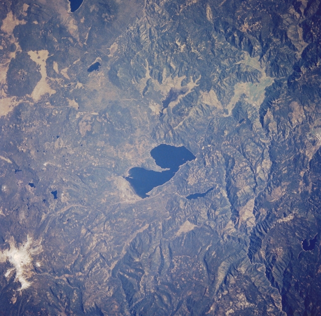 |
| STS058-085-072 Lake Almanor and Lassen Peak Volcano, California, U.S.A. October 1993 This low-oblique, northwest-looking photograph features the dark blue waters of Lake Almanor. Impounded at the Big Meadows Dam across the north fork of the Feather River, Lake Almanor supplies water power to many industries and communities in the region. Visible near the top left of the photograph is the snowcapped stratovolcano Lassen Peak, which last erupted in 1915. Clear-cutting timber patterns appear as small rectangles in both Lassen National Forest northwest of Lake Almanor and Plumas National Forest to the south. Two small reservoirs--Mount Meadows Reservoir and Butte Valley Reservoir--are visible east and north, respectively, of Lake Almanor. The extreme western portion of Eagle Lake is visible near the top right of the photograph. |
| Images: | All Available Images Low-Resolution 378k |
|
| Mission: | STS058 |
|
| Roll - Frame: | 85 - 72 |
|
| Geographical Name: | USA-CALIFORNIA |
|
| Features: | L. ALMANOR, MOUNT LASSEN |
|
| Center Lat x Lon: | 40.5N x 121W |
|
| Film Exposure: | N | N=Normal exposure, U=Under exposed, O=Over exposed, F=out of Focus |
| Percentage of Cloud Cover-CLDP: | 0 |
|
| Camera:: | HB |
|
| Camera Tilt: | LO | LO=Low Oblique, HO=High Oblique, NV=Near Vertical |
| Camera Focal Length: | 100 |
|
| Nadir to Photo Center Direction: | The direction from the nadir to the center point, N=North, S=South, E=East, W=West |
|
| Stereo?: | Y | Y=Yes there is an adjacent picture of the same area, N=No there isn't |
| Orbit Number: | |
|
| Date: | 1993____ | YYYYMMDD |
| Time: | GMT HHMMSS |
|
| Nadir Lat: | N |
Latitude of suborbital point of spacecraft |
| Nadir Lon: | E |
Longitude of suborbital point of spacecraft |
| Sun Azimuth: | Clockwise angle in degrees from north to the sun measured at the nadir point |
|
| Space Craft Altitude: | nautical miles |
|
| Sun Elevation: | Angle in degrees between the horizon and the sun, measured at the nadir point |
|
| Land Views: | VOLCANO, FOREST, FAULT |
|
| Water Views: | LAKE |
|
| Atmosphere Views: | |
|
| Man Made Views: | |
|
| City Views: | |
|
Photo is not associated with any sequences | ||
| NASA Home Page |
JSC Home Page |
JSC Digital Image Collection |
Earth Science & Remote Sensing |
|
This service is provided by the International Space Station program and the JSC Earth Science & Remote Sensing Unit, ARES Division, Exploration Integration Science Directorate.

|