
Geographic Region: USA-CALIFORNIA
Feature: EAST OF DEATH V., PART. FRM.
|
Geographic Region: USA-CALIFORNIA Feature: EAST OF DEATH V., PART. FRM. |
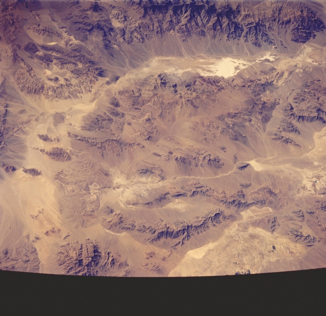 |
| STS058-083-031 Death Valley, California, U.S.A. October 1993 Death Valley, the lowest land elevation in the United States at 282 feet (86 meters) below sea level, is the elongated graben near the bottom of the picture. The actual location of the lowest spot is the highly reflective, white area in the northern end of the playa. The eastern slopes of the Panamint Range flank the western side of the valley. To the east, the Amargosa River and its valley are aligned in a north-south orientation. Extensive talus cones are apparent as subtle color changes surrounding the base of hills and mountains. |
| Images: | All Available Images Low-Resolution 314k |
|
| Mission: | STS058 |
|
| Roll - Frame: | 83 - 31 |
|
| Geographical Name: | USA-CALIFORNIA |
|
| Features: | EAST OF DEATH V., PART. FRM. |
|
| Center Lat x Lon: | 36.0N x 116.5W |
|
| Film Exposure: | N | N=Normal exposure, U=Under exposed, O=Over exposed, F=out of Focus |
| Percentage of Cloud Cover-CLDP: | 0 |
|
| Camera:: | HB |
|
| Camera Tilt: | 51 | LO=Low Oblique, HO=High Oblique, NV=Near Vertical |
| Camera Focal Length: | 250 |
|
| Nadir to Photo Center Direction: | W | The direction from the nadir to the center point, N=North, S=South, E=East, W=West |
| Stereo?: | N | Y=Yes there is an adjacent picture of the same area, N=No there isn't |
| Orbit Number: | 37 |
|
| Date: | 19931020 | YYYYMMDD |
| Time: | 211807 | GMT HHMMSS |
| Nadir Lat: | 34.8N |
Latitude of suborbital point of spacecraft |
| Nadir Lon: | 113.5W |
Longitude of suborbital point of spacecraft |
| Sun Azimuth: | 218 | Clockwise angle in degrees from north to the sun measured at the nadir point |
| Space Craft Altitude: | 156 | nautical miles |
| Sun Elevation: | 37 | Angle in degrees between the horizon and the sun, measured at the nadir point |
| Land Views: | VALLEY , MOUNTAIN, FAULT |
|
| Water Views: | |
|
| Atmosphere Views: | |
|
| Man Made Views: | |
|
| City Views: | |
|
Photo is not associated with any sequences | ||
| NASA Home Page |
JSC Home Page |
JSC Digital Image Collection |
Earth Science & Remote Sensing |
|
This service is provided by the International Space Station program and the JSC Earth Science & Remote Sensing Unit, ARES Division, Exploration Integration Science Directorate.

|